
Important Geophysical Phenomena - Such As Earthquakes, Tsunami, Volcanic Activity, Cyclone Etc., Geographical Features And Their Location -
“The Himalayas are highly prone to landslides.” Discuss the causes and suggest suitable measures of mitigation.
|
Explain the formation of thousands of islands in Indonesian and Philippines archipelagos.
|
Why are the world’s fold mountain systems located along the margins of continents? Bring out the association between the global distribution of Fold Mountains and the earthquakes and volcanoes.
|
What do you understand by the theory of continental drift? Discuss the prominent evidences in its support.
|
There is no formation of deltas by rivers of the Western Ghat. Why?
|
Major hot deserts in northern hemisphere are located between 20-30 degree north and on the western side of the continents. Why?
|
Changes In Critical Geographical Features (Including Water bodies And Ice-Caps) And In Flora And Fauna And The Effects Of Such Changes.
Discuss the concept of air mass and explain its role in macro-climatic changes.
|
Explain the factors responsible for the origin of ocean currents. How do they influence regional climates, fishing and navigation?
|
India is well endowed with fresh water resources. Critically examine why it still suffers from water scarcity.
|
The states of Jammu and Kashmir, Himachal Pradesh and Uttarakhand are reaching the limits of their ecological carrying capacity due to tourism. Critically evaluate.
|
How far do you agree that the behaviour of the Indian monsoon has been changing due to humanizing landscapes? Discuss.
|
Tropical cyclones are largely confined to South China Sea, Bay of Bengal and Gulf of Mexico. Why?
|
Most of the unusual climatic happenings are explained as an outcome of the El-Nino effect. Do you agree?
|
Bring out the relationship between the shrinking Himalayan glaciers and the symptoms of climate change in the Indian sub-continent.
|
The recent cyclone on the east coast of India was called “Phailin”. How are the tropical cyclones named across the world?
|
Bring out the causes for the formation of heat islands in the urban habitat of the world.
|
What do you understand by the phenomenon of temperature inversion in meteorology? How does it affect the weather and the habitants of the place?
|
Bring out the causes for more frequent landslides in the Himalayas than in Western Ghats.
|
Distribution Of Key Natural Resources, Industries - Across The World (Including South Asia And The Indian Subcontinent);
The effective management of land and water resources will drastically reduce the human miseries. Explain
|
South China Sea has assumed great geopolitical significance in the present context. Comment.
|
Present an account of the Indus Water Treaty and examine its ecological, economic and political implications in the context of changing bilateral relations.
|
Enumerate the problems and prospects of inland water transport in India.
|
In what way micro-watershed Development projects help in water conservation in drought prone and semi-arid regions of India.
|
What are the economic significances of discovery of oil in Arctic Sea and its possible environmental consequences?
|
Critically evaluate the various resources of the oceans which can be harnessed to meet the resource crisis in the world.
|
How does India see its place in the economic space of rising natural resource rich Africa?
|
With growing scarcity of fossil fuels, the atomic energy is gaining more and more significance in India. Discuss the availability of raw material required for the generation of atomic energy in India and in the world.
|
It is said the India has substantial reserves of shale oil and gas, which can feed the needs of country for quarter century. However, tapping of the resources doesn’t appear to be high on the agenda. Discuss critically the availability and issues involved.
|
Factors Responsible For The Location Of Primary, Secondary, And Tertiary Sector Industries In Various Parts Of The World (Including India).
Whereas the British planters had developed tea gardens all along the Shivaliks and Lesser Himalayas from Assam to Himachal Pradesh, in effect they did not succeed beyond the Darjeeling area. Explain.
|
Account for the change in the spatial pattern of the Iron and Steel industry in the world.
|
Why did the Green Revolution in India virtually by-pass the eastern region despite fertile soil and good availability of water?
|
Do you agree that there is a growing trend of opening new sugar mills in the Southern states of India? Discuss with justification
|
Analyze the factors for highly decentralized cotton textile industry in India
|
------------------------------------------------------------------------------------------------------
Hurricanes
Hurricanes are giant, spiralling tropical storms that can pack wind speeds of over 160 miles (257 kilometres) an hour and unleash more than 2.4 trillion gallons (9 trillion liters) of rain a day. These same tropical storms are known as cyclones in the northern Indian Ocean and Bay of Bengal, and as typhoons in the western Pacific Ocean.
Katrina’s devastation was a result of the failure of government flood protection systems, violent storm surges, a chaotic evacuation plan and an ill-prepared city government.
| ||
Savanna Climate
The Savanna or Sudan climate is a transitional type of climate found between the equatorial forests and the trade wind hot deserts. It is confined in tropics and best developed in Sudan where dry and wet seasons are most distinct, hence the name Sudan Climate.
· The annual precipitation is less than that of tropical monsoon climate.
· The monthly temperature hovers between 70 F to 90F.
· The prevailing winds in the regions are trade winds.
ROLE OF FIRE IN SAVVANNA: Natural grass fires are evidently more important for the ecology of savannahs than even rains. In the absence of natural plant eaters, fires are the only practical means of renewing the grass canopy.
| ||
Water Bodies
Distribution in %: Oceans (97.3) > Ice caps (2) > Ground Water (0.68) > Fresh water (0.009) > Inland Seas and salt lakes (0.009) > Atmosphere (0.0019) > Rivers (0.0001).
Salinity is the amount of salt in grams present in 1000 grams of water. Average salinity of oceans is 36 ppt. [parts per thousand]
| ||
Jal Kranti Abhiyan by M o WR
Awareness on water security and water conservation.
Encouraging the utilization of traditional knowledge in water resources conservation and management.
Each Jal Grams – one elected representatives of Panchayat and one representative of water users association (Jal Mitra / Neer Nari). Sujalam Card – logo “water saved, water produced”.
| ||
Ocean Gyres
Three forces cause the circulation of a gyre:
Global wind patterns – Wind drags on the ocean surface, causing water to move in the direction the wind is blowing.
Earth’s rotation – The Earth’s rotation deflects, or changes the direction of, these wind-driven currents. This deflection is a part of the Coriolis Effect.
Earth’s landmasses – Continents and islands - The massive South Pacific Gyre, for instance, includes 100s of KM of Open Ocean. In contrast, the northern Indian Ocean Gyre is a much smaller ocean gyre.
Effects:
The Ocean Conveyor Belt: circulates ocean water around the entire planet. Also known as thermohaline circulation, the ocean conveyor belt is essential for regulating temperature, salinity and nutrient flow throughout the ocean.
Garbage Patches: Ocean gyres circle large areas of stationary, calm water. Debris drifts into these areas and, due to the region’s lack of movement, can accumulate for years. These regions are called garbage patches. The Indian Ocean, North Atlantic Ocean, and North Pacific Ocean all have significant garbage patches.
| ||
Waves vs Tides vs Current
Waves – rising and falling of water on surface of ocean due to wind actions.
Tides – rhythmic rise and fall of ocean water twice a day.
Currents – streams of water flowing constantly on the ocean surface in definite directions. It may be warm or cold.
Spring Tide – during full moon and new moon days – sun, moon and earth are in same line and tide are highest.
Neap Tide – when moon is in first and last quarter, ocean waters get drawn in diagonally opposite directions by gravitational pull of sun and earth resulting in low tides.
High Tide helps - raises water - helps in navigation, fishing – fish come closer to shore. Rise and fall of water due to tides is used to generate electricity.
| ||
Many of areas with “high ranges of tides” are located in the areas of Alaska, Canada, and northern Europe
In the higher latitudes of the northern hemisphere, the continents of North America, Europe, and Asia are pressed closer together. This “constriction” of the oceans creates the effect of a higher range of tides.
That many of the areas of the world with high ranges of tides are in the areas of Alaska, Canada, and northern Europe has created a misconception that the range of tide increases with increasing latitude (as one moves farther from the equator and closer to the poles). This is incorrect.
| ||
Strait vs Isthumus
An isthmus is a narrow strip of land joining two landmasses. Eg: Panama, Kara, Suez.
A strait is a narrow passage of water connecting two large water bodies like seas and oceans. Hormuz, Bering, Bosopheros, Gibraltar, Palk.
Torres Strait (separating Australia and Papua New Guinea) – Arafura Sea and Coral Sea;
Strait of Dover (separating continental Europe and UK) – English Channel (which opens out to the Atlantic Ocean) and North Sea;
Strait of Magellan (separating mainland South America and Tierra del Fuego) – Atlantic and Pacific Ocean;
Denmark Strait (Iceland and Greenland) – Greenland Sea (an extension of the Arctic Ocean) and Irminger Sea (a part of the Atlantic Ocean). The Norwegian island of Jan Mayen lies northeast of the strait;
| ||
Ocean Currents
Ocean currents originate due to: Wind (due to friction and are most dominating cause); Salinity (poles and equator); Temperature; Density variations (caused by Salinity and Temp Variations). Rainfall in equatorial region (increase in water); Occasional events like huge storms, earthquakes.
These currents move water masses through the deep ocean—taking nutrients, oxygen, and heat with them.
Effect /Impact of Ocean currents:
Climate (act like big conveyor belt); Regulate, helping to counteract the uneven distribution of solar radiation reaching earth’s surface.
Navigation (by following the currents ship consumes less fuel and gains more thrust).
Impact on Economy/ Trade and Commerce:
1. Best Fishing grounds of world are where cold and warm currents meet. Eg, Kuroshio and Oya shio currents.
2. Desiccating effect causes desert formation at west coasts and thus no agricultural production takes place. Eg, Atacama Desert in Peru.
3. Warm current allows ports to open and shipping industry to develop in Norwegian region. Saves fuel and time.
| ||
Tsunami
Tsunamis rare in Indian Ocean compared to Pacific: Seismic activity in Indian Ocean is less compared to Pacific.
Note: A 3 hour notice of a potential Tsunami can be given unlike an earthquake. However such systems are rare in Indian Ocean.
Note: The first indication that Tsunami is approaching is the rapid withdrawal of water from coastal region.
| ||
Corals
Corals thrive best under: Warm water (T>20F; Tropical and Subtropical zones) – will not flourish near cold currents that’s why not formed on western coasts of continents; Shallow Water (D >30m; Algae need light); Salty and free from muddish water
Factors threatening Corals: Poorly planned and unregulated Coastal tourism; CC: Rising temperatures; Sediments, Industrial garbage – disposal of chemicals (pollution); Irregular fishing and using trawlers; Invasive species like ‘LIONFISH’ which are threatening lives of Corals; Disease intervention (bacteria, fungi, viruses).
If corals are lost, Oceans would: lose much of biodiversity as corals reefs give shelter and food upon which various species thrive. First level protection against Tsunami. More erosion, waste would flow from Coast to Oceans. Decrease in corals would lead to shifting of fishing community from there.
Corals are rightly called the ‘Tropical rainforests of sea’ – sustain biodiversity in marine life.
Zooxanthalae is reason why corals appear near surface (upto few 100 metres). The corals and algae have a mutualistic relationship.
| ||
Coral Reefs
Corals are skeletons of tiny marine animals called polyps. When the living polyps die, their skeletons are left. Other polys grow on top of the hard skeleton which grows higher and higher, thus forming the coral islands.
· Fringing Reef – a coralline platform lying close to the shore extending outwards from the mainland. The outer edge grows rapidly because of the splashing waves that continuously renew the supply of fresh food. Eg: Zanzibar
· Barrier Reef – is separated from the coast by a much wider and deeper channel or lagoon. They have narrow gaps at certain section to allow water from shores to recede back to open ocean. Such gaps are useful for shipping.
· Atolls – are similar to barrier reef except that they are circular in shape enclosing a shallow lagoon without any land in centre. Eg: Suvadiva Atoll in Maldives
| ||
The richest fishing grounds are located on continental shelves
Shallow water at shelves and penetration of sunlight allows growth of minute plants and microorganisms. They are thus rich in Plankton on which millions of surface and bottom feeding fishes thrive. Thus they are richest fishing grounds.
| ||
The average salinity of Baltic Sea is only 7 while that of Dead Sea is 240
Baltic sea receives fresh water and melts from ice which in effect reduces the salinity of this sea. While Dead sea does not have influx of fresh water and being enclosed inland it has a high rate of evaporation, thereby raising the salinity to very high.
| ||
The temperature of Ocean water varies both horizontally and vertically
The cold currents from north, Labrador etc, help reduce the temperature. Ports of eastern Canada are this ice bound. Warm currents like North Atlantic Drift warm the coast and thus temperature is raised at, for eg, Norwegian Coast.
Vertically the temperature decreases with increasing depth. For 1200 feet it reduces very rapidly almost 1 degree F for every 60 feet. Thereafter the decrease is slow upto 3000 feet. Beyond this the decrease is scarcely noticeable.
| ||
The dominant influence on the circulation of ocean currents is wind
The Planetary winds change the direction of ocean currents. For eg, in Indian Ocean the direction of ocean currents changes completely with the direction of monsoon winds which come from North East in winter and south west in summer.
| ||
Western coasts in tropical regions receive lesser rainfall in the eastern coasts of continents. Why?
The direction of flow of trade winds. The trade winds are moist, as they have passed over warm seas. Since they are easterlies, they cause greater precipitation on the eastern coasts and run dry on the western coasts and interiors.
Winds blowing over warm currents pick moisture and bring rain while Winds passing over cold currents do not bring rain but make the deserts colder and drier, for e.g. Kalahari Desert.
| ||
Depressions
A low pressure system also known as a Depression occurs when the weather is dominated by unstable conditions.
The recent depressions in Bay of Bengal are mainly due to ITCZ and jet streams as the winter air mass i.e. Polar continental air mass do not enter Indian subcontinent due to effective barrier of Himalayas.
| ||
Cultural Diversity of Mountains
Globalisation effect:
Building dams using funds from World Bank and other such institutions have hampered livelihood of highland people.
As farmers in plains continue to shift to genetic engineered seeds , more pesticides ,weedicides, chemical fertilizers , the eco-friendly methods of agriculture of highland people is becoming more and more unviable economically.
Global tourism to mountains is also straining their sustainable life-style while the benefits of it continue to get accrued to people outside the local community.
Migration effect:
As agriculture continues to be under strain, people of highlands have started moving to cities for jobs. The adverse impacts of it are Loss of community knowledge is occurring. Indigeneous cultural elements like folk song, local food and craft are also vanishing with migration of people.
Climate change effect:
Floods and cloud burst have increased in number and are disrupting local businesses and infrastructure. Erratic rainfall has played havoc with agriculture.
| ||
Severity of Cyclones
Tropical cyclones are created because of Low Pressure created in the ocean.
Recently there have been more cyclones in Bay of Bengal (BOB) and Arabian Sea, and its reasons are –
Rising seas temperature has led to whet local atmospheric conditions and strengthening of cyclones (enhance cyclo-genesis) in AP and TN region. Higher Coriolis force and increase in humidity in lower atmosphere; fresh water from more no. of rivers intensify the cyclones;
ADDING to this increased industrialisation has contributed to greater coastal temperatures that influenced the track of cyclones; IPCC 3rd report has confirmed that South Asia will face intensified cyclones due to human induced climate change.
| ||
Cyclonic Activity resulting in Fog
Fogs in NI due to Cyclonic activity in Bay of Bengal: Cyclonic has brought in humidity in the entire region. This has increased relative humidity to above average levels. The winds are also contributing to a dip in temperature. In some pockets winds have caused temperature inversion. Low wind speed of easterly winds has also aided fog formation.
Fog adversely effects economic activities involving transportation due to low visibility. so the government has launched WIFEX project to understand fog better and improve now-casting and forecasting.
| ||
Desertification
Defined as land degradation process which occurs in dry sub-humid areas as a result of change in climate and human activities. Desertification causes a drop in biological productivity which leads to decline in economic productivity. It further forces farmers into poverty and compels them to migrate.
| ||
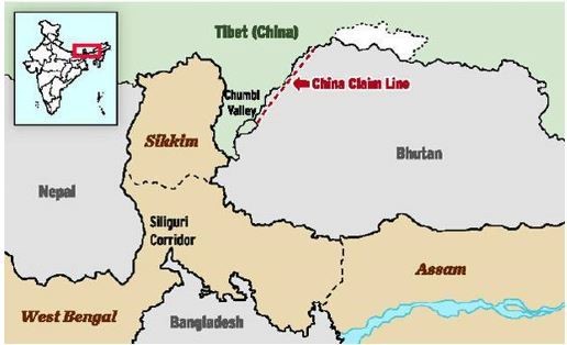
Chumbi Valley
A valley in Tibet at the intersection of India (Sikkim), Bhutan and China (Tibet) in the Himalayas. Two main passes between India and China open up here: the Nathu La Pass and Jelep La Pass.
For China the McMahon Line, stands as a symbol of imperialist aggression on the country. The so-called “Arunachal Pradesh” dispute is China’s most intractable border issue. Because the gap between the positions of China and India is wide, it is difficult for both nations to reach consensus.
| ||
Jet streams
Jet streams are currents of air high above the Earth. They move eastward at altitudes of about 8 to 15 kilometers (5 to 9 miles). They form where large temperature differences exist in the atmosphere.
The boundary between the turbulent troposphere and the calm, cold stratosphere is called the tropopause. Jet streams travel in the tropopause.
They are faster in winter when the temperature differences between tropical, temperate, and polar air currents are greater.
They cause a convergence of air aloft and subsidence near the surface, resulting in intensification of high-pressure systems. As such, jet streams are often described as weather makers. Jet streams supply energy to surface storms and direct their path.
Polar JS: A belt of powerful upper-level winds that sits atop the polar front. The winds are strongest in the tropopause.
[Jet Stream within Earth's molten core]
| ||
Wind
Movement of air from high pressure area to low pressure area is called wind. Its three types are:
1. Permanent Winds – Trade winds, westerlies and easterlies – blow constantly throughout a year in particular direction.
2. Seasonal Winds – change direction with seasons – Eg: monsoons.
3. Local Winds – blow only during particular period of the day or year in a small area. Eg. Land and Sea Breeze. Loo.
Homeostasis – sudden changes evoke short-term, rapid response via the nervous and hormonal system.
Acclimatization is an adaptive change, a gradual long term process, generally to climate of the surrounding.
| ||
Indian Climate
Salient Features of Indian Climate:
1. Three Distinct Seasons – Warm and dry, Cool and dry, and Monsoon.
2. Seasonal reversal of winds (monsoon) due to upward and downward movement of ITCZ and associated pressure changes
3. Seasonal variations in wind pattern (NE Trade winds) due to pacific oscillations (ENSO)
4. High Pressure vs Low Pressure over the Indian subcontinent owing to differential heating of land and the oceans.
5. Huge variation in temperature across N-S and E-W stretch – wide temperature range in areas like Thar desert and low range of T near coastal areas of East Coast; heavy rainfall in Mawsynram.
6. Winter rainfall owing to western disturbances (Punjab) and NE retreating monsoon (TN).
7. Cyclonic rainfall post-Monsoon months in East Coast.
8. Role of Himalayas – preventing from Siberian Freezing winds.
| ||
El Nino Southern Oscillation vs Madden Julian Oscillation vs Indian Ocean Dipole
ENSO cycle is a scientific term that describes the fluctuations in temperature between the ocean and atmosphere in the east-central Equatorial Pacific (approximately between the International Date Line and 120 degrees West).
So, unlike ENSO, which is stationary, the MJO is an eastward moving disturbance of clouds, rainfall, winds, and pressure that traverses the planet in the tropics and returns to its initial starting point in 30 to 60 days, on average.

In scientific terms, the IOD is a coupled ocean and atmosphere phenomenon, similar to ENSO but in the equatorial Indian Ocean.
IOD is defined by the difference in sea surface temperature between two areas (or poles, hence a dipole) – a western pole in the Arabian Sea (western Indian Ocean) and an eastern pole in the eastern Indian Ocean south of Indonesia. The IOD affects the climate of Australia and other countries that surround the Indian Ocean Basin, and is a significant contributor to rainfall variability in this region.
 | ||
Humidity, Precipitation and Clouds
Relative humidity - hygrometer (which comprises wet and dry bulb thermometer). RH is ratio between actual amount of water vapour and the total amount the air can hold at a given temperature, expressed as percentage.
Mist and fog – both are condensation of water vapour in / on dust and other particles like smoke from houses or factories.
a. Only difference between them is that mist contains more moisture than fog.
b. Mists are frequent over mountains while Fogs are common over sea.
Cirrus and stratus clouds – cirrus clouds are formed at high altitudes; thin, detached and feathery – associated with fair weather and brilliant sunset. Stratus clouds are layered clouds, very low, uniformly grey and thick; reduce visibility of aircrafts.
| ||
Evolution of Atmosphere and Hydrosphere on Earth and Comparison with Mars
There are three stages in the evolution of present atmosphere:
1st – loss of primordial atmosphere (H and He gone).
2nd – hot interior of earth contributed to evolution of atmosphere.
3rd – composition of atmosphere was modified by the living world through the process of photosynthesis (Add. Of N and O).
Continuous volcanic eruptions released water vapour and gases. As earth cooled, water vapour condensed – rains occurred which dissolved CO2 in rainwater – oceans formed.
Mars has a thin atmosphere — too thin to easily support life as we know it. ... about 100 times thinner than Earth's, and it is 95 percent carbon dioxide. Initially the earth or even the atmosphere of earth was not conducive for development of life.
| ||
Hot Hydrogen in Thermosphere
Following significance –
It suggests that current atmospheric models are missing some key physics that impacts many different studies, ranging from atmospheric escape to the thermal structure of the upper atmosphere.
Changes our current understanding of the H distribution and its interaction with other atmospheric constituents. It raises a question about H atoms' sources of origin.
It affects the study of water cycle. For forming water u need, 2 molecule of H and 1 molecule of O. i.e. H20. So if many H atom says in Mars case lose out of Gravity, then amount of H decreases which may affect the formation of water n thus the cycle process.
| ||
Noctilucent Clouds
The mesosphere is the coldest of the atmospheric layers. It is cold enough to freeze water vapour into ice clouds. One can see these clouds if sunlight hits them after sunset. They are called Noctilucent Clouds (NLC). NLCs are most readily visible when the Sun is from 4 to 16 degrees below the horizon.
| ||
Ozone Destruction
During winter in the Polar Regions, aerosols grow to form polar stratospheric clouds. The large surface areas of these cloud particles provide sites for chemical reactions to take place. These reactions lead to the formation of large amounts of reactive chlorine and, ultimately, to the destruction of ozone in the stratosphere.
| ||
Direct and indirect sources to study the interior of earth
Direct - Surface rocks or rocks we get from mining areas. Scientists working in ‘Deep Ocean Drilling Project’ or ‘Integrated Ocean Drilling Project’. Molten Magma from Volcanic eruption.
Indirect - Change in thickness of earth. Meteors. Gravitation, Magnetic field, seismic activity.
| ||
Heat Zones of Earth
Torrid Zone – 0 to 23 ½ degree – mid day sun is exactly overhead at least once a year – max heat.
Temperate Zone – 23 ½ to 66 ½ degree – mid day sun never shines over head – moderate heat.
Frigid Zone – 66 ½ to 90 degree – sun does not rise much above horizon – very cold.
| ||
Continental Drift Theory
The theory was regarding distribution of oceans and continents. According to Wegener, all the continents formed a single continental mass (PANGAEA), a mega ocean (PANTHALASSA) surrounded by the same. Evidences in support:
1. Matching of Continents (at 1000 fathom line instead of current shoreline). Shorelines of Africa and South America facing each other have a remarkable match.
2. Rocks of Same Age across Oceans. The belt of ancient rocks of 2,000 million years from Brazil coast matches with those from western Africa.
3. The earliest marine deposits along the coastline of South America and Africa are of the Jurassic age.
4. Occurrence of rich placer deposits of gold in Ghana coast and absolute absence of source rock in the region (Gold bearing veins are in Brazil).
Force a2 Wegener: Pole fleeing force (rotation of earth-causes bulging at equator) and Tidal force (sun, moon).
| ||
Drift Theory vs Plate Tectonics
PT talks about Plates, meeting point ie. Fault lines are site of volcano, EQ, the three movements, force is heat.
DT talks about land and ocean masses. Forces are two. Evidences cited.
| ||
Plate Tectonics
A Tectonic Plate, also called lithospheric plate it is a massive, irregularly-shaped slab of solid rock, generally composed of both continental and oceanic lithosphere.
A plate may be referred to as the continental plate or oceanic plate depending on which of the two occupy a larger portion of plate.
Plate boundaries:
Divergent – plates pull away from each other. Sites where plates move away from each other are called Spreading sites. Eg: Mid-Atlantic ridge.
Convergent – crust is destroyed as one plate dived under another. Location where it occurs is Subduction zone. Eg: Two Oceanic Plates, or Two Continental Plates or Oceanic-Continental.
Transform – Crust is neither produced nor destroyed as plates slide horizontally.
Latest findings made in understanding Plate Tectonics:-
Axial seamount = It refers to a live recording of volcano mountain. The volcano rising from Juan de fuca ridge demonstrates it. It supports the divergent movement.
After 2012 Sumatra Indonesia earthquake in Indian Ocean the Indo Australian plate broke into many plate. It was mainly due to slipping of plate in interpolated and hence the activation of Barren volcano happened.
Zealandia: It’s a new continent. It broke from Antarctica 100 million years and from Australia 80 million years ago. Its formation supports movement of plates.
Heat from the base of the mantle contributes significantly to the strength of the flow of heat in the mantle and to the resultant plate tectonics. Buoyancy is created by heat rising up from deep within the Earth’s core.
| ||
Major divisions of Ocean Floor
1. Continental Margins (CM) – transition between continental shores and deep-sea basins.
a. They include continental shelf, slope, rise, and deep oceanic trenches.
2. Deep-sea basins – or Abyssal Plains are extensive plains that lie between CM and MOR
3. Mid-Oceanic Ridges (MOR) – interconnected chain of mountain system within the ocean. LONGEST MOUNTAIN CHAIN on THE SURFACE OF EARTH though submerged.
| ||
Sea Floor Spreading
Hess (1961) argues that constant eruptions at the crest of oceanic ridges cause the rupture of Oceanic crust and the new lava wedges into it, pushing the oceanic crust on either side. The ocean floor, thus spreads.
He further maintained that ocean floor that gets pushed due to volcanic eruptions at the crest, sinks down at the oceanic trenches and gets consumed.
Verified using these phenomena:
1. It was realised that all along the mid-oceanic ridges, volcanic eruptions are common and they bring huge amounts of lava to the surface in this area. The sediments on the ocean floor are unexpectedly very thin.
2. The age of the rocks increases as one moves away from the crest.
3. The ocean crust rocks are much younger than the continental rocks.
| ||
Earthquake
Release of energy which generates waves that travel in all directions – it occurs along a fault. *A fault is a sharp break in the crustal rocks.
· The point where the energy is released – Focus or Hypocentre.
· The point on the surface nearest to the focus – Epicentre.
Three types of Earthquake Waves -
1. P waves or longitudinal waves or 1o waves - parallel to direction of wave => causes stretching and squeezing of material.
2. S waves or transverse waves or 2o waves - perpendicular to wave direction => create troughs and crests in material that they pass.
3. L waves or surface waves.
Both P and S waves penetrate the interior of the Earth while surface waves do not. Due to this, P and S waves are known as "body waves". The body waves interact with the surface rocks and generate new set of waves called “surface waves”. The denser the material, the higher the velocity. ** S waves are more destructive and case displacement of rocks.
Earthquake waves get recorded in seismographs located at far off locations. However, there exist some specific areas where the waves are not reported. Such a zone is called the ‘shadow zone’. It is due to the S wave.
S-waves can travel only through solid materials. This feature helps to understand the structure of the interior of the earth. A better understanding of earthquakes, volcanoes, etc, how atmosphere formed, study earth’s magnetic fields. All these help find solution to challenges faced upon by humanity.
Types of EQ:
1. Tectonic Earthquakes – generated due to sliding of rocks along a fault line.
2. Volcanic Earthquakes – confined to areas of active volcanoes.
3. Collapse Earthquakes – region of mining activity where roof collapses causing minor tremors.
4. Explosion Earthquakes – ground shaking due to explosion of chemical or nuclear devices.
5. Reservoir induced Earthquakes – occur in areas of large reservoir.
M/s:
· Richter scale – energy released during the quake (Range: 0-10).
· Mercalli scale – intensity scale taking into account the visible damage (Range: 1-12).
| ||
REASONS BEHIND FREQUENT OCCURENCE:-
· Folding and faulting (fracture occurs in the plane on which the Earth’s crust resides); Volcanic activity; Plate tectonics; Nuclear bombs; Construction activities (Blasting of rocks); Underground mining (Shock waves); Dams and reservoirs; Landslides; Injecting liquid waste into the ground (many parts of India, Industries do this); Creating high rise buildings on inappropriate land.
| ||
Types of Volcano
Based on Activity - Active, Dormant, Extinct.
Based on Intensity - Hawaii, Basic* Lava, Vulcania, Vesuvius, Pelee.
Based on Cone (Lava Type) - Shield or Dome (Wide Dia, flattened), Composite Cone (New Eruptions add to height), Parasitic Cones (Dykes from main conduit of Composite Cone).
*Basic èless acidic => less silica content => less viscous, highly fluid => less sloping, i.e. gently sloping. [Heavier]. ^ = very high in humankind history.
The volcanic dust shot very high of which the coarser fragmental rocks are collectively called pyroclasts.
During eruption the top is blown off or collapses into vent widening the orifice into a large crater. Caldera is greatly enlarged depressions [of craters]. Water may fill such depressions is called crater or caldera lake.
| ||
Geology of India - categorized
In following eras, in increasing chronological order:
· Precambrian super-eon
· Phanerozoic
· Palaeozoic
· Lower Paleozoic
· Upper Paleozoic
· Mesozoic
· Cenozoic
· Tertiary period
· Quaternary period
1. Khasi hills, one of youngest, belong to Tertiary period.
2. Alluvium eroded from Himalayas found in Indo-Gangetic plain belongs to Quaternary period.
3. Deccan plateau in India is one of the oldest.
| ||
Anthropocene
The International Commission on Stratigraphy decides epochs, eons and eras to mark earth’s geological history.
The current epoch is named Holocene which started 12000 years ago with start of agriculture which brought changes throughout earth’s landforms and climate.
Today however human influence has increased enormously. Plastic waste and pollution due to humans has increased and is bringing widespread changes to earth like global warming. Anthropocene was suggested, therefore, to rename the current epoch.
| ||
Grass Roots Actions and CC
Climate change is one of the greatest tragedy of commons, affecting all.
“The risks from climate change are serious enough to require grass-roots action, rather than waiting for a grand international agreement.”
Build Resilience of Communities (harvest, native species, overgrazing, biodiversity); Carbon Sequestration (tree planting); Eliminating unsustainable agricultural practices. [Mitigating]
Renewable Energy, Energy Efficiency, Corporates (Green Buildings, private vehicles, pool), Life styles (less waste, less emission); [Adaptation]
| ||
Climate Change
Two causes - Astronomical and Terrestrial
Astronomical - Changes in solar output associated with Sunspot activities (sunspots increase => wetter and storminess);
Milankovitch Oscillations Theory (wobbling of earth and changes in earth's axial tilt => alter insolation received);
Terrestrial - Volcanism; Anthropogenic - GHG.
| ||
Farm Crisis and Climate Change
Farmer suicides account for 11.2% of all suicides in India. Nearly 60,000 farmer suicides in the last 30 years in India can be linked to global warming. India’s farmers are already hit regularly by strong storms, extreme drought, heat waves and other extreme weather events.
1. Reliance on natural rainfall.
2. Weeds have become more prolific and are expected to invade new habitats as global warming increases. This has resulted in rise in the use of pesticides and insecticides.
3. While crops could be impacted, farm animals would be even more susceptible to changes in the climate (more stress due to rising temp).
4. Country had many farm lands on coastal areas and CC will have larger effects here.
| ||
Forests and Climate Change
Forest loss and degradation is both a cause and an effect of our changing climate. This relationship was explicitly recognized in the recently held UN Climate Change Conference, COP 21 in Paris in 2015.
Forests: “carbon sinks”; cut GHG; ecosystems services; wood-fuels as a benign alternative to fossil fuels;
Pandora’s box of major global threats, such as hunger, poverty, population growth, armed conflict, displacement, air pollution, soil degradation, desertification and deforestation are intricately intertwined with and all contribute to climate change.
| ||
Antarctica
“Antarctica is a climate stabilising factor.”
· Distribution of sea surface temperature; Albedo of ice-surface; Sea ice isolates the water from the air, reducing the transfer of energy between winds and ocean currents; Greenhouse gas reservoir ~Permafrost.
Impact of human activities is evident from thinning of the Larsen Ice Shelf. Biodiversity loss - species like emperor penguins which depend on sea ice to complete their life cycle are at risk. Ozone hole; when global warming melts sea ice, Earth becomes a better absorber of heat, which encourages further warming.
| ||
Health of River, Aquifers and Catchment Systems
Water percolates down until it reaches the impermeable layer of rock. Then it starts accumulating above the impermeable layer and saturates the rock. The permeable layer in which the water is stored is known as aquifer.
The surface of the saturated area is called the water table. The depth of the water table varies greatly according to relief and to the type of rocks.
| ||
Wetlands
Recently, TN State government conceded the GoI-owned Kamarajar Port Ltd’s (KPL) request to divert 1,000 acres of the hydrologically sensitive Ennore wetlands for industrial installations.
Ennore famous for its ecological importance supporting various marine ecosystem and aquatic lives. At times of distress situation like 2015 flood, heavy rains during retreating monsoon, tropical cyclone like Vardah, this wetland site always emerged as a shelter reducing the adverse effects of natural phenomena. Its coastal plants prevent salty water from sea to get mixed with ground providing freshwater source during water crisis as Chennai always prone to. Habitat for Migratory birds like Pelicans. Goes against CoI tenet under A48A.
Move will have some benefits – employment, increased development opportunities, better infra.
Here environment is more important than development. Plus, Goes against the SDGs objectives of promoting sustainable environment.
| ||
Other topics:
Forest Fires, El Nino and La Nino, Vagaries of Monsoon, Unusual Warm weather in Arctic, Afforestation, Global Warming and Siachen
| ||
Commons
A common is a shared resource managed by a community who create rules to make the resource durable. The resource cannot be monopolised by one or a group of individuals; it has to be as opened as possible. The resource is not private or public; it is a third thing: a common. These can vary from global commons as space, the Antarctica continent to local commons such as wetlands, ponds, parks and beaches.
Types of environmental commons: Community forests in Nepal. Irrigation systems of New Mexico (Acequia).
Efforts: Chipko movement, WHO’s call to western world to delink life saving drugs from IP laws. Arctic Council, CLCS(Commission on Continental Shelf).
Planned infrastructure like Smart Cities Mission have been incorporated with specific focus on creating commons like playground for recreational purposes.
Internet space should be common to enable innovative ideas.
Avoid “free riding of resources” to avoid ” nature’s curse”.
| ||
Teesta
Teesta River is far from a diplomatic issue between India and Bangladesh. It concerns with a geographical and economic challenges of the region.
Teesta flows through Sikkim and Northern districts of West Bengal before entering Bangladesh and meeting Brahmaputra.
Diplomacy:- Federal governments of both India and Bangladesh are attempting to finalise a water sharing agreement on the lines of Ganga River Water Treaty of 1996. This will be a big boost to the bilateral relations as it is a major diplomatic concern since last one decade.
Complex Challenges beyond diplomacy:-
· The territory-water availability ratio is very high as compared to India. West Bengal has 176 BCM of water as reserves whereas Bangladesh with comparable size has 1211 BCM.
· The paddy in Kharif season and the pulses of Rabi season are heavily dependent on Teesta River in the region.
· The dams that were designed to moderate floods have created floods by releasing excess water at the peak of the monsoon.
· Besides West Bengal farmers the tribal areas of Sikkim consisting of Lepcha and Bhutia are also affected. Their lives and economy are disturbed due to the lean phase of river from November to April (when it is most required) and also due to indiscriminate dam building on Indian side of the river.
Way forward:- Although A253 gives power to UoI to enter into any trans-boundary river water-related treaty with a riparian state, the Centre cannot do it arbitrarily. Clearly this issue not just diplomatic and rather concerns with the Geographical and Economical challenges of the region.
Any treaty should consider the social, political and economic impact of such a treaty in the catchment area.
| ||
River linking
Stated benefits of Project: Water Security, Irrigation availability, transfer from surplus to deficient = uniformity.
Shah committee also pointed out that the linking of rivers will affect natural supply of nutrients for agricultural lands through curtailing flooding of downstream areas.
Usually rivers change their course and direction in about 100 years and if this happens after interlinking, then the project will not be feasible for a longer run
Cost of the project (Rs 5,60,000 crore in 2001, Rehab, Relief), Ecological disaster, Rivers habitat.
* Against linking of Ken and Betwa – MP Wildlife board member
· We may not have either park or paani.
· The area under submergence is most productive for wildlife.
· It submerges the habitat of chowsingha and other species like vulture.
· It is not the quantum but the quality of habitat that will be affected.
· Secondly it will bisect the park and reduce habitat for wildlife.
| ||
Water (21st) is Oil (20th C)
Importance of water goes beyond that of oil because there are some alternatives to oil like natural gas, wind, solar or nuclear energy but alternative to water is only water.
Water’s strategic relevance to today’s world –
· Terrorist organizations like Islamic State (IS) can take control of important water resources to force the resilient towns or villages into submission. Further, attacks on water infrastructure would ruin the life of people living in the vicinity of water body.
· Trans-national rivers have attained the greater importance at present. Water conflicts over such rivers are increasingly rising among the riparian states. For eg conflict between India and Pakistan over river Indus and its tributaries, conflict over river Nile in North Africa etc.
· Control over seas and water bodies have given strategic advantage to the nations controlling it. For eg areas like South China Sea, Andaman Sea, Malacca Strait, Black Sea etc have been critical in such aspects.
· Oceans and Rivers are most important sources of the food through activities like fishing for coastal and inland areas.
| ||
Digital Industrialisation / 4th IR
The fourth Industrial Revolution embraces new technologies that are fusing physical, digital and biological worlds, impacting all disciplines, economies and industries. Digital industrialization includes use of digital technologies along with physical infrastructure.
Benefits of Digital Industrialization:
· Worldwide reach: any organization will be able to function anywhere, without inhibitions. Example: Uber-global transport.
· Business processing cost will go down.
· Better utilisation of data, data analytics.
As data is the new oil, multilateral organizations like RCEP, ASEAN in the name of promotion of e-commerce are restricting the policy making on digitalization.
India’s readiness:
· Emergence of many startups in domains like Robotics, manufacturing, computing aided by government policies of StartUp India, Make in India.
· Digital infrastructure creation – BharatNet, StartUp Hubs, Increased Mobile connections, availability of smart computers and Supercomputers like PARAM etc.
India’s challenges:
· In the backdrop of countries asserting for liberalizing e-commerce in WTO, India may get hurt by predatory business of global giants like Amazon, Microsoft, etc.
· Without robust cyber security, Indian data is susceptible to attack e.g. SBI Bank accounts details compromised, Union Bank of India recently fell prey to hacking.
· Repercussion on Employment generation.
| ||
Sunrise industry
An emerging industry that is considered a favourable investment venture by investors. They attract risk capital and become a crucible for growth and more importantly employment. Eg: Fisheries, floriculture (particularly hill states), food processing etc.
| ||
The food processing industry in India
32% of India’s total food market.
· Synergises pillars – agriculture and manufacturing.
· Coupled with e-NAM -> backward and forward linkages between industry and farmer producer organizations and bring better returns to farmers.
· Current contribution to: Manufacturing GDP 14%, India’s exports 13% and 6% to total industrial development.
· Others: reduce post-harvest loses.
However, there are certain bottlenecks that need to be overcome to realize the true potential of this sector:- Cartelisation at the APMC level, poor market yard infrastructure and lack of compliance with international quality norms which render our processed food products not worthy of exports.
Government role: Tax holiday to Food Processing SEZs, Giving industrial licenses, establishing modern industries and food parks.
Way forward:- Schemes such as the NMFP, National Cold Storage Scheme, Merchandise Exports from India etc, Mega food park policy, 100% FDI in trading of food products are needed to provide much needed impetus to this sector.
More R&D, innovation especially in RTE, RTH (Ready to Eat/Heat – are in high demand, handy for busy consumer) – CFTRI can pursue development of ecological and socially sustainable and standardized food processing protocols.
Contract Farming could also be promoted to provide an assured market to our farmers.
| ||
Rare Earth Elements
A set of 17 elements in the periodic table i.e. the 15 Lanthanides and Scandium and Yttrium. They are of relevance in the modern industry due to their unique magnetic, luminescent and electrochemical properties.
Irony – While they are called ‘Rare’ Earth Elements, they are not so rare in occurrence. However, they are not present in concentrated form and generally not exploitable commercially. It is their special property and ability that it is of utmost importance in military applications.
Worldwide Scramble for REE – Asymmetry: The global reserves of REE are contained primarily in bastnaesite and monazite. The former is mainly found in China and the US while the latter is found in Australia, Brazil, China, India and South Africa.
India currently has a little over 2% share of global output of rare earths though it has the 3rd largest sources of RE (mostly east coast). Their production has also increased post-1995. But, more than 97% supply lies with China. China supplies poor quality. Russia only produces for domestic needs.
Technology gives a different dimension to any resource. REE is available in many places but the technology is suitable to extract. From Mining to OEM – there’s a serious lack of technically trained personnel.
Steps India has taken:- Set up IREL (Indian Rare Earth Limited) for commercial scale processing of monazite sand.
Plant commissioned in Gopalpur, Odisha to produce REE up to 2500 T/year.
India’s emergence as a supplier has been a respite for Japan which has had to depend on China for sourcing of REE. Japan is even ready to provide technology.
| ||
GST alters economic geography
"GST will streamline operations that over time most of the economic activity in Country will become digital".
| ||
Geo-mapping
‘Geo-mapping’ is a visual representation of the geographical location of geo-tagged assets layered on top of map or satellite imagery.
| ||
Geo-tagging
‘Geo-tagging’ is the process of adding geographical identification like latitude and longitude to various media such as a photo or video.
It provides users the location of the content of a given picture.
The National Remote Sensing Agency (NRSA), ISRO (Hyderabad) has a software platform, Bhuvan that allows users to explore a 2D/3D representation of the surface of the Earth.
Several assets are created in the states under various schemes of various Ministries. Monitoring of such wide spread activities is of paramount importance to states and Government of India to understand flow of funds, inventorying the assets, bringing in transparency, planning of assets for future, and finally informing the farmers about the facilities available. Geo-tagging helps with such monitoring.
Ministry of Rural Development for MGNREGA. Department of Land Resources for watershed activities in the states. Postal department has also geo-tagged the post offices.
| ||
Stromatolites
Key to study the evolution of life on earth [study of life on Mars]. They are major constituent of the fossil record of first forms of life on earth.
They provide evidence that life existed on earth 3.7 billion years ago.
Cyanobacteria were responsible for one of the most important global changes that the Earth has undergone. Being photosynthetic, cyanobacteria produced Oxygen as a by-product.
| ||
T-phi grams
A tephigram is one of the thermodynamic diagrams commonly used in weather analysis and forecasting. IMD derives T-Phi Grams using the INSAT-3D sounder. It is useful for predicting cyclones.
| ||
Ratooning
It is the practice of growing a Sugarcane crop from the stubbles of previous crop. Ratoon crop also matures earlier and gives more or less same yield as of normal sugarcane.
However, only one ratoon should be taken because incidence of pests and diseases increases and deterioration of soil takes place.
| ||
Organic Farming
In this type of farming, organic manure and natural pesticides are used instead of chemicals. NO GENETIC MODIFICATION is done to increase the yield of the crop.
| ||
Permaculture
A permaculture garden is more than an organic garden. It is a system of agricultural and social design principles centered on simulating or directly utilizing the patterns and features observed in natural ecosystems. There is reuse of waste and waste water.
| ||
Mixed Cropping vs Mixed Farming
In mixed cropping for eg, Sorghum, Bajra and cowpea are grown in rainfed conditions to reduce crop failures. Wheat and Mustard for better utilization of soil nutrients. That is, two or more crops together in the same piece of land simultaneously.
While in mixed farming, growing of crops is done together with raising of livestock.
| ||
Upland rice vs Lowland rice
Upland rice is grown in rainfed, naturally well-drained soils without surface water accumulation. Upland rice varieties are drought tolerant, but have a low yield potential. Farmers in these environments are among the poorest and usually cannot afford to apply (many) external inputs such as fertilizers.
Lowland rice cultivation practices in water logged fields. India mostly grows lowland rice, since the yield of upland rice is much lower and cannot ensure our food security.
| ||
Crop Data
· WB, UP and Andhra Pradesh (undivided) are the highest producers of rice, in order.
· Gujarat, TN and Andhra Pradesh (undivided) are the highest producers of groundnuts, in order.
· Gujarat, Maharashtra and Andhra Pradesh (undivided) are the highest producers of cotton, in order.
· Karnataka and Maharashtra follow Rajasthan in coarse cereals production.
· WB, UP and Bihar are the highest producers of potato, in order.
| ||
Types of Droughts in India
IMD – Meterological drought – 1st – fall in rainfall
MoWR – Hydrological drought – 2nd – drying of wells, rivers
MoAgri – Agricultural drought – 3rd – non-sustainable agriculture – independent of 1 and 2.
Ecological Drought: productivity of a natural ecosystem fails due to shortage of water
| ||
Pulses - Why does India have to import?
Pulses are grown in both Seasons – Kharif and Rabi. Pulses need less moisture and survive even in dry conditions. Despite India being the largest producer of Pulses in the World, India imports Pulses to meet domestic demand.
Some of the reasons why domestic production in not enough.
1. Huge demand due to high population
2. Pulses are exported despite a shortfall in domestic production and higher consumption.
3. Incentive structure is distorted against pulses by high government subsidies for cereals (e.g. MSP).
4. Pulses are risky crops as per farmers. For e.g. in UP, Nilgai destroys huge pulse crops within hours.
5. Little protection is offered by the local government.
6. Productivity of pulses is lower than world average, and just one-third of that in US and Canada. Poor quality of seeds and input.
| ||
Challenges to Fish Production in India
India has tropical climate in which fish cannot be preserved for a long time. Heavy expenditure on refrigeration and deep freezing increases the market price of the fish.
Indian coast does not have many gulfs, bays, estuaries and backwaters as is the case with Norway. As such, it lacks good fishing grounds.
Marine fishing in India is a seasonal phenomenon. Strong winds during the monsoon season accompanied by tropical cyclones often hinder the fishing operation.
| ||
Area under Permanent Pastures and Grazing Lands: Most of this type land is owned by the village ‘Panchayat’ or the Government. Only a small proportion of this land is privately owned. The land owned by the village panchayat comes under ‘Common Property Resources’.
Cultivable Waste-Land: Any land which is left fallow (uncultivated) for more than five years is included in this category. It can be brought under cultivation after improving it through reclamation practices.
Current Fallow: This is the land which is left without cultivation for one or less than one agricultural year. Fallow is a cultural practice adopted for giving the land rest. The land recoups the lost fertility through natural processes.
Net Area Sown: The physical extent of land on which crops are sown and harvested is known as net sown area.
| ||
Tight oil/ gas - Oil that is found in reservoir rocks with very low permeability which allows only horizontal drilling. Such that massive hydraulic fracturing is necessary to produce the well at economic rates.
This definition also applies to coalbed methane, shale gas, and tight carbonate reservoirs. The Krishna – Godavari inland and offshore basins said to have good prospects of tight oil and tight gas reserves from the conducted field studies.
CBM refers to methane that is found in coal seams. It is formed during the process of coalification, the transformation of plant material into coal. CMM refers to methane released from the coal and surrounding rock strata due to mining activities.
| ||
Minerals found in India and distribution.
· Iron – High grade iron ore. The mineral is found mainly in Jharkhand, Odisha, Chhattisgarh, MP, Goa, Maharashtra and Karnataka.
· Bauxite – Major producing areas are Jharkhand, OD, Chhattisgarh, MP, GJ, Maharashtra and TN.
· Mica – mainly occur in JH, Bihar, AP and Rajasthan. India is LARGEST producer and exporter of mica in the world.
· Copper – mainly produced in Rajasthan, MP, Jharkhand, Karnataka and AP.
· Manganese – Lie in Maharashtra, MP, Chhattisgarh, Rajasthan, Gujarat and TN.
· Limestone – major producing states are Bihar, JH, OD, MP, Chhattisgarh, RJ, GJ and TN.
· Gold – Kolar in Karnataka has deposits of gold in India. These mines are among the deepest in the world which makes mining of this ore a very expensive process.
· Salt – obtained from seas, lakes and rocks. India is one of world’s leading producers and exporters of salt.
Petroleum In India: Digboi in Assam, Bombay High in Mumbai, deltas of Krishna and Godavari rivers.
Natural Gas In India: Jaisalmer, KG delta, Tripura and some areas off shore in Mumbai.
Nuclear Material In India: Uranium – Rajasthan and Jharkhand. Thorium in Kerala.
Geothermal Plants In India: Manikaran in HP and Puga Valley in Ladakh.
| ||
Iron And Steel Industry = Basic, Feeder
It is a feeder industry whose products are used as raw material for other industries. Steel is often called the backbone of modern industry.
Oil wells are drilled with steel machinery. Steel pipelines transport oil. Minerals are mined with steel equipment. Farm machines are mostly steel.
8 Tonnes of Coal + 4 Tonnes of Iron + 1 Tonne of Limestone = 1 Tonne of Steel.
Apart from these labour, capital, site and infrastructure is required.
Before 1800 – located where raw materials, power supply and running water were easily avbl.
From 1800 to 1950 – near coal fields and close to canalas and railways.
Since 1950 – on large areas of flat land near sea ports. Because by now the steel works has become very large and iron ore had to be imported from overseas.
| ||
Environmental determinism -> Possibilism -> Neo-determinism
Environmental Determinists argue that aspects of physical geography, particularly climate, influenced the psychological mind-set of individuals, which in turn defined the behaviour and culture of the society that those individuals formed.
For e.g., tropical climates were said to cause laziness, relaxed attitudes, promiscuity and generally degenerative societies, while the frequent variability in the weather of the middle latitudes led to more determined and driven work ethics and thus more civilized and 'stronger' societies.
Possibilism. It argues that the environment only sets certain constraints or limitations, but culture is otherwise determined by social conditions.
Neodeterminism or stop and go determinism is the middle way between both concepts.
| ||
Demographic Trap
Combination of high fertility (birth rates) and declining mortality (death rates) in developing countries, resulting in a period of high population growth rate (PGR).
| ||

What do you understand by seasonal shifting of pressure belts? What impact does it have on the formation of various climatic regions across the globe? Also, discuss its social-economic significance.
Seasonal shift of pressure belts: On the earth’s surface is a direct result of the inclination of the earth’s axis. With the apparent shift of the sun between the tropics, the pressure belts trace its path.

THE SOCIO-ECONOMIC SIGNIFICANCE of the shift of pressure belts is profound –
The most significant impact of the shift of the ITCZ viz Inter tropical convergence zone: Low pressure belt formed near the equator where the trade winds of the Northern and Southern Hemisphere come together.
Further the most profound impact can be seen in the Northern hemisphere due to the complexities created between the continental landmass and the oceans. Due to differential heating between land and the oceans pressure gradients so formed are stronger. In the Southern Hemisphere the belts are fairly stable as the variances in temperature are not much pronounced.
Most visibly they are responsible for Monsoon in India. As the ITCZ shifts northwards due to the apparent shift of the sun towards the Tropic of Cancer the South-Easterly trade winds shift northward and due to the impact of the Coriolis force take a north easterly path. These moisture laden winds manifest themselves as monsoon and determine the agricultural output of the country.
The Mediterranean climate is also a result of the aforementioned phenomenon. It has hot and dry weather during the summer and cold and wet conditions during the winter. As a result it has emerged as a major fruit growing regions in the world and is famous for its vineyards.
Many regional climatic zones such as the Chinese type, Gulf type, Natal type etc are a result of the shifting pressure belts.
Other significance – specialised agriculture (Monsoon – Rice, Mediterranean – Plantation, Olives, Steppe – Fodder and dairy, Savanna – grasses and meat); TRANSHUMANCE; different festivals based on harvesting time.
What do you understand by extra-tropical cyclones and briefly describe how they differ from tropical cyclones? Why do tropical cyclones weaken after landfall?
‘Extra tropical’ are a type of storm system formed in middle or high latitudes in regions of high horizontal temperature variations called frontal zones. As the name suggests these originate outside the tropics. As these are formed over fronts they extend for over 1000kms as compared to tropical cyclones which extend to about 300kms. Their circulations affect the entire troposphere over a region of 1000km and they generally move from west to east across the oceans and continents.
They are the reason for cold winter showers across the north western parts of the Indian subcontinent. Another point of difference is that extra tropical storms disintegrate after a couple of days due to an occlusion. The primary difference is that extra tropical cyclones are formed when two different air masses come together and form a front.
Temperate Cyclones are also called Extra Tropical Cyclones or Mid Latitude Cyclones or Frontal Cyclones or Wave Cyclones.
TROPICAL CYCLONE
|
TEMPERATE CYCLONE
| |
Latitude
|
10-30 N and S
|
30-60 N and S. More pronounced in North due to greater temperature contrast.
|
Frontal System
|
Absent
|
The very cyclone formation is due to Frontogenesis.
|
Size, Formation and Season
|
Limited to Small area;
Only on seas;
Seasonal – Late Summers.
|
Cover a large area;
Sea as well as land;
Irregular – few in summers, more in winters.
|
Rainfall
|
Heavy rainfall but lasts only few hours*or days.
|
Rainfall is slow but stays for days and * weeks.
|
Path and Driving Force
|
East à West
Energy is derived from latent heat of condensation.
|
West à East (Westerlies)
Energy depends on densities of air masses.
|
Influence of Jet streams
|
Not clear
|
Distinct relationships with upper level air flow.
|
Clouds
|
Exhibit fewer varieties – Cumulonimbus, Nimbostratus, etc.
|
Show a variety of cloud formation at various elevations.
|
Intensity, Surface Anticyclones
|
Destructive;
Not associated with surface anticyclones.
|
Not very destructive;
Anticyclones precede and succeed a cyclone.
|
INFLUENCE ON INDIA
|
Both coasts effected. But East Coast is hotspot.
|
Bring rain to NW India (associated instability is called – Western Disturbances)
|
Tropical cyclones get their energy from the heating of the sea and huge masses of vapour under the influence of the trade winds give rise to the formation of the cyclonic winds. This is the prime reason why tropical cyclones weaken rapidly over land as the depletion of moisture and heat hurts the cyclones ability to produce thunderstorms near the storm centre. As a result of the absence of this convection, the cyclone dissipates and dies after landfall.
Explain how process of soil formation depends on a number of factors other than the nature of the parent rock. Elaborate with examples.
The process of soil formation begins with weathering of parent material. Thus the parent rock is the main source for weathered material. Various other factors include –
· Topography – This decides the extent of erosion of the parent rock. Soil layer will be thin on steep slopes and thick over flat upland areas. Eg: Clay formation will take place up on flat lands.
· Climate – This factor increases the rate of weathering and thereby soil formation. The climatic elements involved are moisture, frequency and duration of precipitation – evaporation, humidity and temperature in terms of seasonal and diurnal variations. For Eg, in the regions of hot and wet tropical areas of the Western Ghats, most of the minerals including silica are leached which results in the formation of LATERITE Soil. In the dry climates of Rajasthan, evaporation exceeds precipitation as a result of which salts are deposited to the surface by capillary action resulting in SALINE Soils.
· Biological Activity – Organic acids which form during humidification aid in decomposing the minerals of the soil parent materials. The vegetative cover and organisms help in adding organic matter etc and decide the humus or organic matter of the soil.
· Time – The length of time the process of paedogenesis goes on for eventually determines the nature of the soil. For Eg, Khadar is the newly deposited alluvium and Bhangar is the older alluvium in the Gangetic plains.
Excess of water from precipitation helps in downward transportation of soil components through the soil – eluviation and deposits the same down below – illuviation.
BLACK Soils – Regur = cotton. GJ, MH, KA – Basaltic Origin. S TN – Tirupur – excessive weathering of Gneiss and Granite Rock (Fe). Clayey – no leaching => expands when moist and cracks when dry => self-ploughing. JOWAR, BAJRA, COTTON.
Laterite Soils [4%] – All Hilly – Rajmahal, EG, WG, Satpura. Heavy seasonal rainfall => weathering and leaching (Ca, Mg) => only Fe, Al left => red color. Plantation crops w/ fertilizers. Hard when dry – BRICK.
Red and Yellow Soils [25%] – Less rainfall, Eastern and Southern Deccan Plateau – TN, OD, CT, TS, JH, SE MH, S Kar. Well drained, Weathering of Metamorphic. Sandy => less water retention. Yellow in color in hydrated form. Red in color due to diffusion of Iron.
Desert Soil – Lack moisture.
Peaty Soil – Humid regions - Kottayam, Alappuzha. Black colour, acidic. Excessive wetness of soil.
Alluvial Soil – Riverine, Deltaic, Coastal. Light grey to Ash grey.
Mountain Soil – Boreal Forest Soil, Podzoil, Alpine
Degraded Kind of Soils – SALINE, ALKALINE – not natural but faulty human practices.
Rocks are Igneous, Sedimentary, Metamorphic. Rock Cycle is inter-conversion between them due to heat and pressure effect.
Plutonic or Intrusive Igneous rocks are formed at some depth in the earth’s crust. They are exposed at surface by process of denudation and erosion. Eg: GRANITE, GABBRO, DIORITE.
Volcanic or Extrusive rocks are poured out of volcanoes as lavas and solidify rapidly on earth’s surface. Eg: BASALT. The Lava Plateaux of Deccan Plateau in India.
Metamorphosis (Rocks)
· [S] Clay à Slate
· [S] Coal à Graphite
· [S] Shale à Schist
· [S] Sandstone à Quartzite
· [S] Limestone à Marble
· [I] Granite à Gneiss
Earth’s Crust: Oxygen, silicon, aluminium, iron, calcium, sodium, potassium, magnesium ~ 98% of total crust of earth. Oxygen itself shares 47% by weight followed by Silicon at 28%.
Seawater: Chloride>Sodium>Magnesium>Sulfur>Calcium>Potassium.
Bridgmanite = most abundant mineral in Earth = makes 38 per cent of Earth has finally been named-bridgmanite. For around 50 years, the mineral, a form of magnesium iron silicate found 660 km inside Earth, could not be studied or named because it did not survive the trip to the surface and its properties remained unknown. However, meteorites that fall on Earth have the same element in “frozen” form. X-ray analysis of Tenham, a meteorite that crashed in Australia in 1879 and had bridgmanite grains, revealed that mineral contains high amounts of ferric iron and sodium.
The nature of earth’s surface is a result of various internal and external forces acting on it. Explain.
What are known as Geomorphic processes?
These two forces cause physical stresses and chemical actions on earth materials and bringing about changes in the configuration of the surface of the earth are known as geomorphic processes.
What forces are continuously shaping the landscape?
Endogenic (growing inside).
Land building forces.
|
Exogenic (generating outside).
Land Wearing – erosion causing.
|
a. Sudden Forces - EQ, Volcano, Landslides. Building up of parts of earth’s surface. Eg: Deccan Plateau.
b. Diastrophic forces - All processes that move, elevate or build portions of earth’s crust.
|
a. All Exogenic geomorphic processes are covered under a general term denudation.
b. Weathering, Mass Wasting, Erosion and Deposition.
|
What constitutes diastrophism?
a. Orogenic processes – involve mountain building through severe folding. MOUNTAIN BUILDING PROCESS. Eg Himalayan Ranges.
b. Epeirogenic processes – involves uplift or warping of large parts of earth’s crust. CONTINENT BUILDING PROCESS. EG: Rift valleys such as those in Narmada Valley.
c. Earthquakes.
d. Plate tectonics.
|
How is denudation carried out?
1. Process of wearing away the earth is carried out in 4 phases:
2. Weathering – ; Erosion – ; Transportation – ; Deposition – ;
3. All 4 phases are taking place at different rates in different parts based on – nature of relief, structure of rocks, local climate, and interference by man.
3 types of movements:
1. Heave – heaving up of soils due to frost growth and other causes. Slow.
2. Flow – wet and fast.
3. Slide – dry.
|
Main force behind endogenic geomorphic processes?
Energy within earth generated mostly by radioactivity, rotational and tidal friction and primordial heat from generation of earth.
|
What are Exogenic geomorphic agents and ultimate force behind it?
Those which removes, transports and deposits earth materials, Eg running water, groundwater, glaciers, winds, waves, currents, etc. Ultimate force is Sun.
|
Give an example of enhanced weathering.
Carbonated water is injected into the rocks so that it reacts with Calcium, Magnesium or Silicate material present in Basaltic rocks.
“Carbfix project” is concerned in this way of locking away CO2. It offers hope though the Cost is high, process is reversible and it generates seismic activity.
What is Chemical, Biological and Physical Weathering?
Chemical - extremely slow – due to exposure to air and water (Carbonation, Hydration, Oxidation)
Physical or Mechanical - Exfoliation – rectangular blocks are rounded by splitting away of sharp corners; repeated temperature changes; repeated wetting and drying; salt expansion; **when water freezes it expands by 1/10 of its volume.
Biological Weathering – growth and movement of organisms; Mosses (small flowerless plants) and Lichens (symbiotic association of fungi and algae) absorb elements from the rocks as food and produce organic acids.
Difference between exfoliated domes and exfoliated tors?
Large smooth rounded domes formed due to removal of overlying rock load because of continued erosion – Eg of exfoliation domes – Gengi Hill.
In rocks like granites, smooth surfaces and rounded small to big boulders formed due to differential heating and resulting expansion and contraction of surface layers – Eg of exfoliation tors – Mahab’s stone.
Why natural weathering process is important for mining?
Weathering of rocks and deposits helps in enrichment and concentrations of valuable ores such that they become economically viable for exploitation.
Mining Leases – GoI è Exploration – NMET under MMDA è Infrastructural Development in affected belts – DMF;
Mass Movements:
Slow Movements – ~MOIST TEMPERATE - are of two types
a. Creep – occurs on moderately steep, soil covered slopes – leaning down of fences, telephone poles.
b. Solifluction – slow downslope flowing soil mass or fine grained rock debris saturated or lubricated with water.
|
Rapid Movements ~ HUMID CLIMATES – three types
a. Earthflow – movement of water saturated clayey or silty earth materials down low-angle terraces
b. Mudflow – in the absence of vegetation cover and heavy rainfall
c. Debris Avalanche - with or without vegetation cover and occurs in narrow tracks on steep slopes.
|
Landslides relatively rapid and perceptible movements – four types
a. Slump – slipping of rock debris with a backward rotation with respect to slope (gravity is main role).
b. Debris slide – rapid rolling or sliding of earth debris without backward rotation.
c. Debris fall – near free fall of earth debris from a vertical or overhanging face.
d. Rockslide – sliding of individual rock masses down bedding, joint or fault surfaces.
|
Causes of Debris Avalanche and landslides in Himalayas:
1. Tectonically active.
2. Mostly made of sedimentary rocks and unconsolidated and semi-consolidated deposits.
3. Slopes are very steep.
Compare with Western Ghats - Nilgiris are relatively tectonically active and mostly made up of very hard rocks.
|
Why do then debris avalanche and landslides occur in Western Ghats hills?
1. Many slopes are steeper with almost vertical cliffs and escarpments in WG and Nilgiris.
2. Mechanical weathering due to temperature changes and ranges is pronounced.
3. Receive heavy amounts of rainfall over short periods.
So there is almost direct rock fall quite frequently here.
|
Different Types of Mountains:
FOLD – compressive forces leading to folding along line of weaknesses.
a. Himalayan and Alps, Rockies, Andes – are youngest.
b. Aravalli Range – oldest in world.
c. Appalachians and Urals – old.
|
BLOCK – Faulting of earth’s crust – Horsts (or Block) and Graben (or Rift).
a. Eg. East African Rift Valley.
b. Rhine Valley, Vosges Mountain in Europe.
|
VOLCANIC – ejected, called mountains of accumulation.
a. Eg: Catopaxi (EQ),
b. Mt Kilimanjaro, Mt FUJI (JP)
|
RESIDUAL – evolved from plateaux dissected by rivers.
a. Eg: Deccan.
|
Landform is any recognizable naturally formed surface feature of earth: Plains, plateaus, valleys, mountains as well as small features like hills, canyons and eskers.
Landscape is an umbrella terms which includes six main compositional elements: Landform, Vertical structures, horizontal structures, vegetation, water, climate.
Youth stage
|
Mature stage
|
Old Stage
|
1. Few streams that with poor integration flowing through original slopes.
2. Shallow V-shaped valleys; DEEP gradients.
3. Stream divides are broad with marshes, swamps etc.
4. Waterfalls and rapids may exist where hard rocks are there.
5. TURBULENT FLOW
6. Ex: Indus Gorge Kashmir.
|
1. Plenty streams with good integration; MILD gradients.
2. Still V-shaped valleys but DEEP.
3. Broader meandering floodplains.
4. Water divides turn sharper.
5. Waterfalls and rapids disappear.
|
1. Smaller tributaries flowing over GENTLE gradients.
2. Divides are broad and flat with lakes.
3. Streams meander freely forming natural levees, ox-bow lakes.
4. Most of the landscape is either at or above sea level.
5. ALLUVIAL FAN.
|
When running water (river) tumbles at steep angle over very hard rocks or down a steep valley side it forms a waterfall.
|
As river enters the plain it twists and turns forming large bends known as meanders.
At times river overflows it banks. As it floods, it deposits layers of fine soil and other material called sediments along its banks. This leads to formation of flat fertile floodplain.
|
As the ends of meander loop come closer and closer, in due course of time the meander loop cuts off from river and forms a cut off lake, also called an oxbow lake.
The raised banks are called levees.
The collection of sediments from all the mouths forms a delta.
|
Natural Levees vs Point Bars - As a river overflows its banks during flood, it drops much of its coarser-grained load immediately, forming landforms called Natural levees (on the convex bank – also called slip banks). On the other hand, the deposition that accumulates opposite the cutback (concave bank - the bank that experiences erosion) is called point bars.
Peninsular Rivers flow through broad shallow valleys. Their course is more or less short and straight. Due to hard rocks and lack of silt and sediment they do not form meanders and ox-bow lakes. Most of them rise in the Western Ghats flow eastwards and fall into the Bay of Bengal, forming fertile deltas.
Himalayan Rivers have long courses and are engaged in erosional and depositional activities. Passing through the mountains, they make deep gorges. They bring huge quantities of silt and sediment. In the middle and lower courses they make meanders, ox-bow lakes, flood plains and deltas.
Bhabar – rivers after descending from mountains deposit pebbles in a narrow belt of about 8 to 16 km in width lying parallel to the slopes of Shiwaliks. It is known as bhabar belt and all the streams disappear in this bhabar belt.
Terai – south of bhabar belt, the streams and rivers re-emerge and create a wet, swampy and marshy region known as terai. This region is thickly forested and full of wildlife. It was here that migrants from Pakistan were settled.
Bhangar – largest part of northern plain is formed of older alluvia that lies above the flood plains of rivers and presents a terrace like feature. This is known as bhangar. The soils in this region contains calcareous deposits locally known as kankar.
Khadar – The newer, younger deposits of flood plains are called khadar. They are renewed almost every year and so are fertile, thus, ideal for intensive agriculture.
Bhurs denote an elevated piece of land situated along banks of Ganga River – due to dust wind.
Reh or Kallor comprises barren saline efflorescence of drier areas in Uttar Pradesh and Haryana. Reh areas have spread in recent areas with increase in irrigation.
Dooars – Alluvial floodplains in north-eastern India that lie south of outer foothills of Himalayas and north of Brahmaputra River basin.
The most dominant and almost exclusive type of geomorphic process in limestone areas is that of processes of solution and deposition by the action of the groundwater.
The erosional landforms produced by the action of the groundwater are pools, sinkholes, lapis and limestone pavements. In areas of alternating beds of rocks with limestone caves are also formed. The depositional landforms in limestone areas by the action of ground water are stalactites, stalagmites and pillars.
When the limestone (CaCO3) (any limestone or dolomitic region) reacts with the underground water, it dissolves to form KARST. There is appreciable erosion without rocks undergoing weathering.
1. Sea waves continuously strike at rocks. Cracks develop. Over time they become wider. Thus, hollow like caves are formed on rocks. They are called sea caves.
2. As the sea caves cavities become bigger and bigger only the roof of the caves remain, thus forming sea arches.
3. Further erosion breaks the roof and only walls are left. These wall like features are stacks.
4. The steep rocky coast rising almost vertically above sea water is called sea cliff.
5. The sea waves deposit sediments along the shores forming beaches.
When ice sheets reach down to the sea they often extend outwards into the polar water and float as ice shelves. When they break into individual blocks they are called icebergs.
Cirque – deep, long and wide trough or basins with very steep concave to vertically dropping high walls at its head as well as sides.
Cirque or tarn lakes – A lake of water can be seen quite often within the cirques after the glacier disappears. Such lakes are called cirque or tarn lakes.
Horns – form through the head ward erosion of the cirque walls. If three or more radiating glaciers cut head ward until their cirques meet, high, sharp pointed and steep sided peaks called horns form.
Serrate ridges or Arête – the divides between cirque side walls or head walls get narrow because of progressive erosion and turn into serrated or saw-toothed ridges sometimes referred to as arêtes with very sharp crest and a zig-zag outline.
Glacial till – The unsorted coarse and fine debris dropped by the glaciers is called glacial till. These are monotonous, featureless and may be arable in some place.
Eskers and Drumlins give indication of direction of glacial movement.
Moraines = Long ridges of deposits of glacial till. There are 8 types of moraines of which 6 are recognizable:
1. Ground, Lateral || Push – only formed by glaciers that have retreated and then advance again.
2. Terminal, Median || Recessional – form at the end of glaciers so they are found across valley and not along it.
3. Supraglacial # – material on surface of glacier, dust from atmosphere, etc.
4. Englacial # – material trapped within ice.
# - exist only when glacier exists.
When Wind blows it lifts and transports sand from one place to another. When it stops blowing the sand falls and gets deposited in low hill – like structures. These are called sand dunes.
When grains of sand carried are very fine and light, the wind can carry it over long distances. When such sand is deposited over large areas, it is called loess. Large deposits of loess is found in China.
Rocks in the shape of mushroom are called mushroom rocks. Winds erode lower section of rock more than upper part and thus such rocks have narrower base and wider top.
Tropical Evergreen Forests
a. Also called Tropical Rainforests.
b. No particular dry season.
c. Trees do not shed their leaves altogether.
d. Sunlight cannot penetrate ground.
e. Hardwood trees – Rosewood, ebony, mahogany.
Hardwood trees are useful for making furniture, transport and construction materials. Eg: Sal.
Tropical moist f includes: EG f; Tropical Semi-EG f, Tropical Moist Deciduous f and Littoral, Swamp f.
|
Tropical Deciduous Forests
a. Monsoon forests – India, North Australia, C America.
b. Seasonal changes.
c. Shed leaves in dry season to conserve water.
d. Hardwood trees – sal, teak, neem, shisham.
|
Temperate Evergreen Forests
a. Mid latitudinal coastal regions – eastern margin of continents.
b. SE USA, S China, SE Brazil
c. Hard and Soft wood – oak, pine, eucalyptus.
|
Temperate Deciduous Forests
a. Higher latitudes – NE margins of continents
b. USA, China, N Zealand, Chile, awa Coastal W Europe.
c. Shed leaves in dry season.
d. Oak, Ash, Beech.
|
Mediterranean Vegetation
a. Western and south western margins of continents.
b. California in USA, SW Africa, SW S America, SW Australia.
c. Hot dry summers and mild rainy winters.
d. Oranges, figs, olives and grapes – people have removed natural vegetation here.
|
Coniferous Forests
a. Higher latitudes of northern hemisphere.
b. Taiga = pure or untouched in Russian.
c. Tall, softwood evergreen trees – also seen in higher altitudes – Himalaya
d. Very useful in making pulp – paper, newsprint, matchboxes, packing boxes.
e. Chir, Pine, Cedar.
f. Silver fox, mink, polar bear.
|
Tropical Grasslands
a. Both side of equator and extend till tropics.
b. Grass can grow very tall – 4 meters.
c. Savannah of East Africa
d. Campos of Brazil
e. Llanos of Venezuela
f. Elephants, Leopards, Deer, Giraffes, Zebras
|
Temperate Grasslands
a. Mid latitudinal zones and interior of continents.
b. Grass is short and nutritious.
c. Pampas of Argentina
d. Prairie of N America
e. Veld of S Africa
f. Steppe of C Asia
g. Downs of Australia
h. Wild buffaloes, bison, antelope
|
CHINA Type - Warm Temperate Eastern Margin
· WARM MOIST SUMMER AND COOL DRY WINTER
· Strongly modified by MARITIME INFLUENCE
· UNIFORM DISTRIBUTION OF RAINFALL throughout
· TYPHOONS (intense tropical cyclones) in Late Summer
· Also called Gulf type (SE USA): Continental heating induces cooler air flow from Atlantic
· Also called NATAL type (SE Australia, S Africa, S Brazil): Narrowness of continents, dominance of maritime influence eliminate the monsoonal elements
· SOUTHERLY BURSTER – violent cold wind (New South wales) or PAMPERO – cold wind in Argentina: sudden fall in temperature è rain
BERG WINDS (SE Africa) – hot, dry wind (~Chinook/ Fohn) è brings high T and oppressive weathers
|
BRITISH Type - Cool temperate Western Margin
· Under Permanent influence of Westerlies all-round the year; MUCH CYCLONIC ACTIVITY
· Fairly Mild Winter, Moderately Warm Summer
· Adequate rainfall throughout year with Winter MAX
· Natural vegetation: Deciduous Forest (leaves shed in Winter)
|
LAURENTIAN TYPE - Cool Temperate Eastern Margin
· Intermediate between British and Siberian type
· Features of both Maritime and Continental Climates
· ABSENT IN THE SOUTHERN HEMISPHERE
· Cold dry winters and Warm wet summers
· Summer Maximum due to EASTERLIES from OCEANS
|
SIBERIAN - Cool Temperate Continental Climate
· Experienced only in NORTHERN HEMISPHERE
· Predominantly EVERGREEN CONIFEROUS Forest
· TAIGA = Russian for Coniferous
· Bitterly Cold Winter of long duration and Cool Brief Summer;
· No Month without some form of moisture
|
ARCTIC or Polar Climate
· Permanently Snow covered: TUNDRA Vegetation
· Winters are long and very severe
· Summers are cool and brief
· Convectional Rainfall is absent: 1. Low rate of evaporation and 2. Low moisture;
· pptn is in form of Rain and Snow
|
Explain why:
· The predominant forest trees of Eastern Australia are Eucalyptus: Heavier rainfall and a well distributed rainfall makes eastern margin home to number of valuable timber species. Timber species of Australia that is grown is Eucalyptus.
· USA accounts for more than 50% of world’s production of corn (maize) but only 3% of world exports: Because most of the corn is used for fattening animals mostly cattle and pig; ** apart from its ease of cultivation in respect of soil, labour and climatic requirements, corn’s most outstanding feature is its PROLIFIC YIELD (बहुफलदायक). It gives almost twice as much food (mainly starch) per acre as wheat or other cereals.
· The Netherlands is a major exporter of butter and cheese: Cattles are kept on scientific lines, and intensive basis; and the temperate western margin type climate is almost ideal for intensive dairying;
· Market – gardening is a product of Urbanization: There are more towns and cities owing to high industrialization. The bulk of city comprising city dwellers, factory owners, civil servants want fresh provisions of fruits, vegetables, eggs, meat, etc. Therefore, intensive market gardening is carried out in specialized areas, normally small. As the crops are perishable and conveyed by high speed trucks this is also called as Truck Farming
· The annual precipitation of Leningrad is not more than 19 inches: Due to their continentality and lack of sea influence.
Crop
|
Climate
|
Soil – best or doable
|
Region – Leading
|
RICE
|
HIGH Temperature
High Rainfall
High Humidity
|
Alluvial Clayey Soil which can retain water
|
China
India, Japan, SL and Egypt
|
WHEAT
|
Mod Temperature
Mod Rainfall during growing season
Bright sunshine at harvest
|
Well drained loamy soil
|
USA, Canada, Argentina, Russia, Ukraine, Australian and India
|
MILLETS (Jowar, Bajra, Ragi)
|
Low Rainfall
High to Mod Temp.
|
Less fertile and Sandy Soils
|
India, Nigeria, China and Niger
|
MAIZE (/Corn)
|
Mod Temperature
Mod Rainfall
Lots of Sunshine
|
Well drained fertile soils
|
North America, Brazil, China, Russia, Canada, India and Mexico
|
COTTON
|
High Temperature
Light Rainfall
210 frost free days
Bright sunshine for growth
|
Black and or Alluvial Soil
|
China, USA, India, pakistan, Brazil and Egypt.
|
JUTE (Golden Fibre)
|
High Temperature
Heavy Rainfall
Humid climate
|
Alluvial Soil
|
India, Bangladesh
|
COFFEE
|
Warm and Wet Climate
|
Well drained loamy soil – Hill slopes are suitable
|
Brazil
Columbia, India
|
TEA
|
Cool climate
Well distributed high rainfall throughout year for growth of tender leaves
|
Well drained loamy soils – gentle slopes, large labour to pick the leaves
|
Kenya, India, China, SL
|
While Jute enjoys significant ecological and economic advantages over other fibers yet it has been struggling to survive. In this context discuss the problems associated with the Jute industry in India. To what extent can the Jute Technology Mission address the issue.
Jute has been cited as ‘golden fibre’ due to the following reasons:-
1. It is 100% bio-degradable and hence environment friendly.
2. It is also used for erosion control in the form of geo-textiles. In this sense jute is versatile can be blended with other materials.
3. The industry also provides employment to about 0.26 million workers and supports 4 million farm families.
However the industry has been facing various problems:
|
JUTE TECHNOLOGY MISSION, 2006:
|
Illegal import of jute from countries such as Nepal and Bangladesh which are cheaper due to the various cash subsidies they enjoy.
Labour relations are strained – labour-intensive industry.
Uneconomic running of the mills. Under-utilization of capacity.
Competition from synthetic substitutes.
Demand for Plastic based products has increased (cost, trend, preference..). Our cultural setup is not such as to use jute, Khadi.
Dilution of the Jute Packaging Material Act of 1987 which has exempted cement and fertilizer industry. Similar demand has been made by the sugar industry. This reduces the market for jute products.
|
Development of quality seeds,
Better methods of retting and extraction technologies and
Develop technologies to commercialize and diversify the use of jute.
It has however, failed to bring about necessary changes to provide much needed traction to the jute industry.
|
Way forward:-
R&D – Produce quality jute, reduce cost.
Develop natural instinct among people using innovation – China has innovated 80% jute with 20% plastic and produced from carpets to curtains.
The Himalayas are rich in minerals:-
· Sapphires are found in Zanskar Range.
· Alluvial gold is found in nearby Indus river bed.
· Copper ore is found in Baltistan.
· Vale of Kashmir has iron ores.
· Coal seams are found in Jammu.
· Kashmir even has bauxite.
· Ladakh possess borax and sulphur deposits.
· Nepal, Sikkim, Bhutan have reserves of coal, mica, gypsum and iron ores.
It is more than tourism and hydroelectricity that Himalayas can provide us. However in exploiting the natural reserves for economic use certain challenges are present:-
· The Himalayan region is prone to seismic activities. Current methods of mining and exploitation can further such shocks.
· Deforestation and mining can have serious repercussions on the environment and climate of Indian subcontinent. The Himalayas are source and path of rivers. Such activities can affect the quality of water and life supported by it.
· The region of Baltistan is occupied by Pakistan while Ladakh and Leh are armed region. With connectivity still behind and security a challenge in these areas, exploitation is a very far ahead task.
|
Resources available in Arctic region:
1. Gold in Alaska
2. Nickel near Russia
3. Petroleum in Kinai Peninsula, Alaska
4. Copper at Rankin island, Canada
5. Coal in Spitsbergen and Alaska
6. Iron ore deposits in Labrador, Sweden
7. Timber and Fur in Eurasia
8. Fisheries across the Arctic Coast
Abundance of valuable natural resources has impacted geopolitics around ARCTIC Region:
1. To take control over Arctic resources and navigation many countries are in race as it is governed by UNCLOS and cooperated by Arctic council with additional bilateral agreements.
2. Norway is contesting with Russia for rights over ARCTIC. While USA and European countries are supporting Norway, Russia is developing friendship with China and has even got it observer status in Arctic Council.
3. India too is given observer status in Arctic and together with Norway is doing scientific experiment in Arctic region, eg: Himadri.
4. With longer ice free periods and the energy requirement of countries shall lead to new scramble for Oil and Gas across ARCTIC shores.
5. Fishing is another debate area which is having impact on geopolitics.
|
MONSOONS:
Two factors are mainly responsible for this very strong development of monsoons:
(i) Vast size of the Indian subcontinent and adjacent seas;
(ii) Very high and extensive mountain systems of the Himalayas in the north, extending in an east-west direction, thus posing a formidable physical barrier between tropical and polar air masses.
- The high mountain chains of the Himalayas which border the subcontinent on three sides work as both a break and motor at the same time. During the winter season, they prevent the penetration of the cold polar air masses from Siberia into the subcontinent, while in summer, the Himalayas do not allow the equatorial maritime air masses to cross the Himalayas and force them to curve round the north-west.
- According to the thermal concept, during the period following the Spring Equinox (March 23), the sun starts its apparent northward shift. As a result, the areas lying north of the equator (tropics and sub-tropics) - get a progressive high incidence of solar radiation.
- The effect of this phenomenon on the Indian subcontinent is seen in the form of intense heating of the vast northern plains and the adjoining highlands. As a result, a massive low pressure trough is formed extending from the Punjab plains in the north-west to the Bengal delta in the east.
- This low pressure zone attracts wind regimes from the adjoining areas, from short distances in the beginning. But as the level of solar incidence reaches its peak during May-June, the pressure gradient between this low pressure trough and the adjoining seas is so great that it attracts winds from as far as the south of the equator. Accompanying this process and helping this pull of wind regimes is the development of some high pressure centres—in the Indian Ocean, Arabian Sea and over Australia (it being the winter season in Australia).
- The wind patterns which are prevalent south of the equator are actually the south-east trade winds which blow from the south-east towards the north-west. These winds, attracted by the low pressure trough over the Indian subcontinent, while moving north of the equator, turn in a clockwise direction (or towards the right), following Ferrel’s law. This shift in direction is brought about by the earth’s rotation. Now, the originally south-east trade winds become south-west monsoons blowing towards the north-east.
- At this juncture, the Inter- Tropical Convergence Zone (ITCZ) also shifts northwards. The ITCZ is the hypothetical line where the north-east trade winds from the northern hemisphere and the south-east trades from the southern hemisphere meet. The south-west winds now approaching the Indian peninsula have to travel a long distance over the Indian Ocean.
- During their long journey, these winds pick up large amounts of moisture and by the time they reach India they are oversaturated. Here, they are known as the south-west monsoons which get divided into the Arabian Sea branch and the Bay of Bengal branch because of the shape of peninsular India. There moisture-laden winds cause heavy rainfall on the windward sides.
IMPACT OF EL NINO AND LA NINA:-
- El Niño and La Niña are mutually opposite phenomena, during which an abnormal warming or cooling of sea surface temperatures is observed in the Pacific Ocean along the equator, off the coast of South America.
- Together they constitute what is known as the El Niño-Southern Oscillation system, or ENSO for short. The two phenomena impact weather and climate events across the world, including the Indian monsoon.
- The most prominent droughts in India, six of them, since 1871 have been El Nino triggered droughts, including the recent ones that occurred in 2002 and 2009. Nevertheless, it is important to note that all El Nino years do not lead to drought in India.
- Going by historical data of 135 years from 1880 to 2014, about 90% of all evolving El Nino years have led to below normal rainfall and 65% of evolving El Nino years have brought droughts.
- From this fact, one thing is clear that El Nino years adversely affect the weather in India in terms of Monsoon rain, with very few exceptions. During an El Nino year, the rainfall is generally below the normal average, which has its negative bearing on crop production.
To fight drought and water scarcity in India:
1. Stress resistant crops – Crops that can grow in less water – with assistance from ICAR and KVK such crops will help mitigate risk and vulnerability.
2. Early warning system – Partnering with ISRO, IMD – develop systems like Resourcesat and Bhuvan that help inform about quick weather changes.
3. Rain water harvesting – use traditional methods as well as modern way of storing water according to region and suitability (Harness the work of MNREGA workers).
4. Micro-irrigation – in light of PMKSY, efforts must be laid on per drop more crop – farmers must be helped to use drip and sprinkler irrigation – this will reduce wastage of water.
5. Cropping pattern – using m-Kisan and Agriculture extension services, farmers must be encouraged to use mixed cropping pattern, incentivise horticulture crops millet-pulses sowing. This will help balance them with water guzzling crops like rice sugarcane.
6. Government policies should be properly researched and forwarded – like MSP for Pulses should be reasonable and profitable for farmers to actually plant pulses. To tackle the menace of excess concentration of yield and thereby less realisation of good price, e-NAM based solution where all-India market would be open for all be developed.
7. Collective efforts, Community based storage and conservation of water – this has proved successful in many parts of India, eg Marathwada – where village turned into Oasis with water management and now they grow crops such as grapes, ginger, chillies).
8. Stop unnecessary use for luxury purposes – where such need be water should not be pumped from ground but such big bodies must have own water treatment and recycle plants.
· inter linking of rivers* to ensure water surplus-deficit.
· PMFY – Insurance – (crop insurance, weather insurance) Farm level;
· Income insurance; Low interest loan; Land Consolidation; Contract farming
· Role of Cooperatives.
The individual, community, government have roles to play. One man’s effort could be an inspiring story but not good enough to tackle the menace on large scale every year.
Managing the drought and water scarcity would require to shift from rainfed to irrigation based agriculture. Mihir Shah Recommendations on increasing this from current 45% is necessary.
Geography predetermines conflicts.
Rivers creates conflicts. Location of state creates conflicts (Border States). Uneven distribution of natural resources (minerals) create conflicts. Hilly vs plain tribes in conflicts. Fisherman Issue. Insurgency Issue.
India’s gateway to the east – Manipur has been at loggerheads with the central govt. since time immemorial. The conflict can be understood on two parameters- the sense of isolation from mainland and internecine conflict within tribals, migrants and outsiders. The geographical reasons for the same can be enlisted as follows –
1. The difficulty of terrain and distance from center of power led to neglect from the colonial rulers and the trend continued post-independence.
2. Poor communication lines led to lag in economic development via resource mobilisation/tourism which increased the local conflict for meagre economic avenues.
3. Division of land administratively into revenue generating land/valley and non-administered hills led to conflict between the natives on same grounds.
4. The neighbouring states added to the diversity of ethnic Tribals with their own notion of homeland- and hence increased conflict on “encroachment” by migrants - for eg- between nagas and kukis.
5. The strategic location on international border and internal conflicts increased military presence which further reduced scope of peaceful and sustainable development.
Manipur like any other North east state strives for its own unique identity while looking forward to the central govt for its incorporation in mainland’s growth story unfolding at a great pace. The need of the hour is to reduce geographical separation (Eg- Kaladan multimodal project) and initiate a multi-stakeholder dialogue (like being done in J&K) for smooth transition and sustainability of the region.
INDIA's SUGAR INDUSTRY:
The Indian sugar industry is a key driver of rural development, supporting India’s economic growth. The industry is inherently inclusive supporting over 50 million farmers and their families, along with workers and entrepreneurs of almost 500 mills, apart from a host of wholesalers and distributors spread across the country. The industry is at a cross roads (चौराहा) today, where it can leverage opportunities created by global shifts in sugar trade as well as the emergence of sugarcane as a source of renewable energy, through ethanol and cogeneration.
Reasons for changes in sugar industry:
1. The continuous droughts for 2 to 3 years in southern states have led to the decrease in the production of sugarcane in these states.
2. This fall in the production has disrupted the sugar supply within the domestic environment.
3. Mills in Karnataka and TN have sought permission for duty-free imports of raw sugar under the tariff rate quota (TRQ) system, which will help improve their capacity utilisation and also bridge the hitherto non-existent demand-supply gap in the region.
Recent changes in sugar industry in India and all around the world:
1. Emerging businesses like fuel ethanol and structural changes globally including the removal of EU subsidies have provided new horizons for the sector.
2. Fundamental changes in the consumer profile and the demonstrated ability of the sector to continuously ensure availability of sugar for domestic consumption has diluted the need for sugar to be considered as an essential commodity.
3. The industry can improve its cost competitiveness through higher farm productivity and by managing the domestic production variations through international trade with a focus on countries in the Indian Ocean.
Satellites – LEO, GPS, GSO

Earthquake Prone Zones in India:

Strait of Malacca is the busiest Asian hub transporting oil and other items. It lies between India and China and many ships stop there at Singapore.
The Caucasus region is a 750-mile (1207 km) stretch of land between the Black Sea and the Caspian Sea. Named for the Caucasus mountain range, the region served as a transit point between Europe and Asia before being swallowed up by the Russian Empire.
Divided by the Mekong River, Laos and Myanmar (Burma) separate northern Thailand from China in a highland region known as the Golden Triangle, where most of the world's opium is harvested and processed.
56 Blocks Identified for Shale Gas Production
56 Petroleum Exploration Lease (PEL)/ Petroleum Mining Lease (PML) blocks (ONGC 50, and OIL 6) have been identified by National Oil Companies (NOCs).
These blocks are located in the states of Assam (7 blocks), Arunachal Pradesh (1 block), Gujarat (28 blocks), Rajasthan (1 block), Andhra Pradesh (10 blocks) and Tamil Nadu (9 blocks).
The NOCs will undertake a mandatory minimum work programme in a fixed time frame for shale gas and oil exploration and exploitation
A pyroclastic flow is a mixture of superheated gas, dust, and ash that is heavier than the surrounding air and flows down the flank of the volcano with great speed and force
Novarupta- The Most Powerful Volcanic Eruption of the 20th Century
1912, Alaska was not a US state
area which is now Katmai National Monument
Five important volcanic eruptions of the 20th century. Augustine (1976), St. Helens (1980), Redoubt (1990) and Spurr (1992)
Jet engines process enormous amounts of air and flying through finely dispersed ash can cause engine failure
Impacting the tiny ash particles at high speed is very similar to sandblasting. This can "frost" the jet's windshield and damage external parts of the plane
The more you know about a natural hazard, the greater your chances of avoiding injury or loss.
How Do Diamonds Form?
Contrary to what many people believe, most diamonds do not form from coal.
The most convincing evidence that coal did not play a role in the formation of most diamonds is a comparison between the age of Earth's diamonds and the age of the earliest land plants.
Almost every diamond that has been dated formed during the Precambrian Eon -
Precambrian Eon - the span of time between Earth's formation (about 4,600 million years ago) and the start of the Cambrian Period (about 542 million years ago)
In contrast, the earliest land plants did not appear on Earth until about 450 million years ago - nearly 100 million years after the formation of virtually all of Earth's natural diamonds.
Methods of Diamond Formation
1) Diamond Formation in Earth's Mantle
2) Diamond Formation in Subduction Zones
3) Diamond Formation at Impact Sites
4) Formation in Space
National Helium Reserve
In 1925 the United States established the National Helium Reserve to serve as a strategic supply of helium for use in airships and other defense purposes.
In 1995, Congress decided that the National Helium Reserve was not essential and initiated a program to sell the helium as part of the Helium Privatization Act of 1996.
The market will be undersupplied when National Helium Reserve sales are discontinued.
When that occurs the free market price could shoot up by an order of magnitude as inadequate commercial capacity is stressed.
इंडोनेशिया में माउंट सिनाबुंग ज्वालामुखी फटा
इंडोनेशिया के सबसे सक्रिय ज्वालामुखियों में से एक माउंट सिनाबुंग के फटने से इससे निकला गर्म लावा आसमान में चार हजार मीटर की ऊंचाई तक पहुंच गया
मात्रा द्वीप में मौजूद 400 वर्षों तक सुस्त पड़ा ज्वालामुखी सितंबर से फरवरी के बीच रुक-रुक कर फटता है
अब तक इसके फटने से 15 लोगों की मौत हो चुकी है और 30,000 लोग विस्थापित हो गए हैं
माउंट सिनाबुंग इंडोनेशिया के 120 सक्रिय ज्वालामुखियों में से है


India exports its first warship ‘CGS Barracuda’ to Mauritius

MV Corals passenger ship 400, built @Colombo Dockyard
Coral Biggst Vessel Ever Built In SL (MV Lakshdwp &MV Kavarati: 2011)
MV Lagoons in line 2b given 2 Lakshadweep admin

Hudhud Cyclone -
Hudhud is the national bird of Israel and was suggested by Oman.
Decided in WMO/ESC Asia Pacific - 27th session in Muscat and started since 2004.
Bangl>India>Mal>Myan>Oman>Pak>Sril>Thai>Bangla..
Named by India: Agni, Akash, Bijli, Jal, Lehar.
To be named by India: Megh, Sagar, Vayu

Jan Dhan Yojana: ensure no one is left without bank account.
bank account to unbanked households. 1st phase:by26Jan2015;2nd Phase:by2018
7.5cr households unbanked
provide each bank a/c holder with Rupay debit card
Rs 1 lakh insurance and pension products
JDY is PM Modi’s Financial Inclusion Plan

.Bharat ccTLD (country code top level domain)
NIXI (Nat'l Internet Exc of India) is spearheading: multilingual India
NIXI with CDAC – expert team on IDN (Internationalized Domain Names)
registry.bharat first such domain
ccTLD shared with Dogri, Boro, Santhali, Marathi, Maithili, Nepali, Sindhi-Devanagari

CBFC (Central Board for Film Certification)
statutory body under the MoI&B; regulate public exhib of film
Under Cinematograph Act, 1952; HQ: Mumbai; CEO+CP
CBFC shud b a ratings agency? PCI or AdvertisingCI should decide on cuts?
TNs ban Viswaroopan=> Justice MMudgal Co= exm/upd 1952 act
Earlier SC askd UP govt 2 rem ban on Aarakshan; Law&Order 2b tc by SG
Pahaj Nihalini new CP (from public emm fig)

Central Zoo Authority
autonomous statutory body: WPAct, under the MoEF
192 zoos under its regulation
Can watching miserable captive animals pacing to and fro in cages inspire or teach people?
Beijing zoo, San Diego zoo and Micke Grove (California) zoo - excellent examples

A380
World’s largest and heaviest commercial passenger jet and flying comfort, luxury and efficiency.
Lufthansa to Fly in World's Largest Passenger Jet (520 seater) to Delhi.

Animal Welfare Board:
statutory body under the MoEF,
directed the state governments to strictly implement animal welfare laws
stop illegal killings of camels for food and to take action against offenders.
Punishable offence under the PCA Act 1960

Jaipur Foot-
Jaipur based BMVSS
artificial limbs and other aids
Virendra Raj Mehta- set up Jaipur Foot Centre, Manila Philippines.
Sent for Afghan Nationals

WHAT is UIIC?
India’s leading non-insurer wholly owned by the GoI under MoF
Annual premium of 2013-14 more than Rs.10,000 crores

Sawai Gandharva Mahotsav — 1/ biggest and prestig music fests
Prabha Atre- Famous HMV-recorded Maru Bihag
Classical vocalist also profic- semi-classical genres such as thumri, daadra and ghazal
Kiss of Love protest non-violent protest against moral policing
Started: Kerala; spread oth parts of India
Sp occ but not excl. SC &Del HC: kissing in public: not an obsce act and no crim proc
Moral police term: vigilante groups which act to enforce a code of morality in India
Pink Chaddi C’n nonvio prot mmt by Consortium of Pub-Going, Loose & Fwd Wom
SlutWalk transnat’l mmt of marches Toronto , 2011 subseq occ globally
ag'nst expl rape 2 any aspect woman's appear & call4 an end rape culture

Makaibari Tea- Organic est 1859
record for fetching highest ever price- $450/kg(Indian Auction); $1850/kg abroad
special lot of handcrafted tea from 155 year old Makaibari estate in Kurseong
Chairman – Rajah Banerjee
handmade semifermented- light liquoring Oolong tea;
capt the essence of SS 21June -> ensures highest degree of flavor for any veget

The Turanor Planet Solar
world’s largest solar powered boat
glides across the Venetian lagoon in front of St. Marks square in Venice.

A Format - Used worldwide except North America
Homothetic – i.e. proportions must be maint when sheet is folded on the longest side.
Aspect ratio = constant = root2= 1.4142 i.e. a/b = 2b/a =sq root 2
Lichtenberg is the father of format A (Year 1786)
Ranges from A0 to A10; A4 = 21cm x 29.7cm
A4 is half an A3 and twice an A5; A4 is quarter of an A2 and quadruple an A6.
Fold an A4 you get A5, double it and you get A3.

Sakura: Japanese for Cherry Blossoms; unofficial flower of Japan

Feluda – Pradosh C Mitter- Private Investigator (Bengali)
2nd most famous detective character after Sherlock
1st adventure: Feludar Goendagiri
Writer of the fictional character: Satyajit Ray

Matches made on Sports field:
1. Milkha Singh(Olympic Athlete) + Nirmal Saini(Volleyball Captain): 1962
2. Sania Mirza(Tennis India) + Shoaib Malik(Cricket Pakistan): 2010
3. Avneet Sidhu(Commonwealth Gold Shooter) + Rajpal Singh(Hocket Captain): 2011
4. Heena Sidhu(Commonwealth Gold Shooter) + Ronak Pandit(Pistol Shooter): 2013
5. Dipika Pallikal(Commonwealth Gold Squash) + Dinesh Karthik(Cricket): 2015
MoFP asks PepsiCo to bring down the sugar content in its soft drinks
*As per WHO recommends 6 teaspoons of sugar per day for normal adult
V Krishnaswamy Iyer founded Indian Bank in 1907
TCS – 1st Indian company to cross Rs 5lakhs in market capitalization
second most valuable IT company in world.
ahead of Accenture but behind IBM(was listed 10years ago) in terms of MktCapt.
Magsaysay Awards are given in honor of Ramon Magsaysay, former President of Philippines who died in an air crash in 1957. In the 1950s Ramon Magsaysay brought in land reform program to defuse communist insurgency.
This award is given annually on Aug 31 for the outstanding contribution in the field of Public Service, Community Leadership, Journalism, Literature and creative arts and International understanding. This award is equivalent to Nobel Prize in Asia. It is also awarded to organization and non-Asians working for the benefit of Asia.
In 'Dhanush', Indian Army's Prayers Answered Dhanush', a 155-mm, 45 calibre gun built by the Ordnance Factory Board (OFB), a defence public sector unit
Summer trials held at Pokhran while winter trials held in some areas of Sikkim.
Gun, based on the design and manufacturing technology provided by Swedish gun maker Bofors AG
No new guns have been inducted after the Bofors joined the Indian Army in the late 1980s.
Dhanush is likely to be priced at Rs. 14 crore a piece, less than half of a similar gun manufactured abroad.
Original Bofors gun has a maximum effective range of 27 kilometres, 'Dhanush' can fire a salvo up to 38 kilometres in the plains
The OFB has plans to double its manufacturing capacity from the current 18 guns a year.
Four vaccines added to India's immunisation programme
Universal Immunisation Programme (UIP), including injectable polio vaccine and an adult vaccine against Japanese Encephalitis.
Vaccines against rotavirus, rubella and polio (injectable) will help the country meet its Millennium Development Goals
4 targets that include reducing child mortality by two-thirds by 2015, besides meeting meet global polio eradication targets
National Technical Advisory Group of India (NTAGI), the country’s apex scientific advisory body on immunisation
India’s UIP will now provide free vaccines against 13 life threatening diseases, to 27 million children annually
Diarrhoea caused by rotavirus kills nearly 80 thousand children each year, results in up to 10 lakh hospitalisations, pushing many Indian families below the poverty line.
India developed and licensed its first indigenous rotavirus vaccine, developed under a public-private partnership
Ministry of Science and the Ministry of Health and Family Welfare, along with Hyderabad-based company Bharat Biotech
The UIP also targets rubella, which causes severe congenital defects in newborns, like blindness, deafness and heart defects.
The expanded vaccine immunisation programme could also provide a booster shot for the country’s local vaccine makers
SEBI opens office in Lucknow
SEBI’s mandate given by Parliament is threefold — protection of the interests of the investors in securities, regulation of the securities market and development of the securities market.
LKO office: facilitating the redressal of investor grievances against listed companies and market intermediaries
spread investor education and financial literacy, processing the applications for investment advisors within its jurisdiction
The jurisdiction of the local Office at Lucknow extends to the state of Uttar Pradesh.
Platinum and palladium are likely to maintain their upward looking long-term trend while the eternal favourite gold is expected to move lower.
Much more than the market fundamentals of demand and supply, investor sentiment dictates most movements in the precious metals market
Sentiment impacted by a flurry of factors incl geopolitical tensions (first Russia-Ukraine conflict and now Iraq), supply risks (labour action in producing regions) and somewhat enervated physical demand, in particular for gold.
4/5ths or 85% of the global supply of pd and pt comes from Russia and SA.
Customs duty of 10 per cent ad valorem and export obligation (80:20 scheme) have discouraged gold imports into India
गुरु-शिष्य परंपरा का पावन पर्व गुरु पूर्णिमा
आचरण संपन्न व्यक्ति ही सच्चा समाज सेवक सार्थक संत और सदगुरु हो सकता है।
भारतीय चलचित्र जगत की जिंदादिल वयोवृद्ध अदाकारा जोहरा सहगल (के 102 वर्ष की) निधन
जोहरा सहगल का जन्म 27 अप्रैल 1912 को सहारनपुर में हुआ था।
1932 में बतौर कोरियोग्राफर वो पृथ्वी थियेटर से जुड़ीं।
वह जोहरा सहगल जमींदार मुस्लिम परिवार से ताल्लुक रखती थी परंतु उन्होंने कमलेश्वर सहगल से विवाह किया।
उन्हें संगीत एकेडमी, सम्मान, कालीदास, सम्मान 1998 में पद्मश्री, 2010 में पद्म विभूषण से सम्मानित किया गया।
The Gandhi Peace Prize was instituted by the Government of India in 1995 on the occasion of the 125th birth anniversary of Mahatma Gandhi
This annual award is given to individuals and institutions for their contributions towards social, economic and political transformation through non-violence and other Gandhian methods
It carries a plaque, citation and an amount of Rs. one crore.
Previous recipients of the award include Dr. Julius K. Nyerere, former President of Tanzania; Rama Krishna Mission;
The President of India, Shri Pranab Mukherjee will present the Gandhi Peace Prize for the year 2013 to Shri Chandi Prasad Bhatt
सीईआईबी का गठन 1985 में हुआ था।
यह आर्थिक अपराध पर अंकुश के लिए काम करने वाली सभी एजेंसियों के बीच समन्वय करने वाली नोडल एजेंसी है।
भारतीय राजस्व सेवा (आईआरएस) की वरिष्ठ अधिकारी अर्चना रंजन को केंद्रीय आर्थिक खुफिया ब्यूरो (सीईआईबी) का विशेष सचिव व महानिदेशक नियुक्त किया गया है
Dr Reddy’s initiates voluntary recall of drug from US market
Metoprolol is used alone or in combination with other medications to treat high blood pressure.
It also is used to prevent angina (chest pain) and to improve survival after a heart attack.
Tablet Dissolution is a standardised method for measuring the rate of drug release from a dosage form.
It were manufactured by Dr Reddy’s at one of its Hyderabad manufacturing facilities.
According to USFDA, the recall of the 13,560 bottles has been under ‘Class-II’ classification.
Class II recall is a situation in which use of a violative product may cause temporary or medically reversible adverse health consequences
or where the probability of serious adverse health consequences is remote.
Maruti commissions solar plant at Manesar factory
1 mega watt photovoltaic solar power plant, built on a water lagoon which is used for rain water harvesting
The 1MW solar power plant has been set up at an investment of Rs. 10.3 crore
Company’s philosophy of adopting environment friendly technologies:: high upfront costs, but help bring down CO2 emissions
The solar power plant will help the company offset CO2 emissions to the tune of over 1,200 tonnes annually
सनातन धर्म में भगवान विष्णु के 24 अवतार माने जाते हैं।
कलियुग में बुद्ध और कल्कि के अलावा किसी अवतार की चर्चा नहीं है। इसलिए, साईं अवतार नहीं हो सकते।
सब मनुष्यों का मालिक एक है। साईं भी तमाम मनुष्यों में से एक था। उसका मालिक कौन था?
गौरतलब है कि विभिन्न पौराणिक ग्रन्थों में अवतारों की संख्या अलग-अलग है।
कहीं आठ, कहीं दस, कहीं सोलह और कहीं चौबीस अवतार बताए गए हैं, लेकिन सबसे ज्यादा मान्यता दस अवतारों की है।
गुरु शब्द का शाब्दिक अर्थ यह है कि जो व्यक्ति अंधकार से प्रकाश की ओर ले जाए वह गुरु होता है।
हिन्दू धर्म में गुरु और शिष्य की प्राचीन परंपरा रही है।
Ayonika Paul clinched the bronze medal with a score of 185.3 in the 10m air rifle event of the ISSF World Cup.
Ayonika is currently ranked ninth in the world.
ISSF World Cup in Maribor, Slovenia.
The 71-year-old veteran has sponsored women athletes Ayonika Paul and Pooja Ghatkar – both shooters – as part of the Medals4India campaign initiated by the NGO Olympic Gold Quest.
Olympic Gold Quest is a programme of the Foundation of Sports And Games (founded in 2001),
OGQ started by Indian sporting icons to identify and support Indian athletes with a proven track record and who have the potential to win Olympic gold medals.
Bollywood megastar Amitabh Bachchan, who is a United Nations Ambassador for the girl child, has sponsored the coaching of two women athletes.
India-Born Scientist Named Winner of 2014 World Food Prize
Dr Sanjaya Rajaram has been named the winner of the USD 250,000 World Food Prize
Increasing global wheat production by more than 200 million tonnes in the years following the Green Revolution
cross-breeding winter and spring wheat varieties: : developing plants that have higher yields and a broad genetic base
Founder of this prize: Nobel Peace Prize Laureate Norman E Borlaug:: Founded 1986
यूनेस्को ने दिया प्राचीन रेशम मार्ग को विश्व विरासत स्थल का दर्जा
यह मार्ग 2,000 साल पहले एशिया और यूरोप के बीच व्यापार एवं सांस्कृतिक आदान प्रदान का रास्ता रहा है।
इसके साथ ही बीजिंग में स्थित विश्व के सबसे लंबे कत्रिम जलमार्ग ग्रेट कैनाल को भी यूनेस्को की इस सूची में शामिल किया गया है।
विश्व विरासत समिति ने कतर की राजधानी दोहा में एक सत्र के दौरान यूनेस्को की सूची को मंजूरी दी।
List of UNESCO World Heritage Sites- as of 2014 India
Agra Fort
Ajanta Caves
Ellora Caves
Taj Mahal
Group of Monuments at Mahabalipuram
Sun Temple, Konârak
Kaziranga National Park
Keoladeo National Park
Manas Wildlife Sanctuary
Churches and Convents of Goa
Fatehpur Sikri
Group of Monuments at Hampi
Khajuraho Group of Monuments
Elephanta Caves
Great Living Chola Temples 12
Group of Monuments at Pattadakal
Sundarbans National Park
Nanda Devi and Valley of Flowers National Parks
Buddhist Monuments at Sanchi
Humayun's Tomb, Delhi
Qutb Minar and its Monuments, Delhi
Mountain Railways of India
Mahabodhi Temple Complex at Bodh Gaya
Rock Shelters of Bhimbetka
Champaner-Pavagadh Archaeological Park
Chhatrapati Shivaji Terminus (formerly Victoria Terminus)
Red Fort Complex
The Jantar Mantar, Jaipur
Western Ghats
Hill Forts of Rajasthan
Rani-ki-Vav (the Queen’s Stepwell) at Patan, Gujarat
Unesco world heritage list tops 1,000 to be exact is equal to 1007.
Moving Picture Company (MPC) was the only studio to have been awarded Gold in the VFX (visual effects) category at the recently concluded Cannes Lions 2014.
India is no longer saddled with low-end work like Rotoscopy, which does not require creative inputs
India has progressed to doing high-end work in VFX like compositing, digital matte painting, MatchMove, asset development and FX (simulation).
Three of MPC’s VFX studios around the world were a part of this collaboration – Los Angeles, London and Bangalore.
Since its inception in December 2010, the Bangalore studio, which has a 400-strong team, has delivered high quality visual effects for over 40 Hollywood movies.
Indian talent: Life of Pi, Man of Steel, Prometheus, Skyfall and Madagascar 3: Europe’s Most Wanted (contribution from Bangalore, Hyderabad, Mumbai and Chennai).
"The Telecom Commission further suggested keeping the base price for 900 MHz at 25 per cent higher than what TRAI had recommended". Why 900 Mhz band is superior than 1800 Mhz band?
Understand the laws of physics: It states that the higher you go on the frequency band the lower will be the wavelength that is to say signals will travel a lesser distance. Low frequency signal becomes more potent when it comes to indoor coverage. So to get same if not better coverage mobile companies on DCS 1800 Mhz have to invest more in setting up larger number of base stations than in the GSM 900 Mhz band.
900 Mhz frequency band has been in use for mobile communications globally for over 20 years and as a result technology standards have been better developed compared with 1800 Mhz band, which has been in use only recently. In India, the 900 Mhz band was first allocated in 1994 whereas the 1800 Mhz band started being used from 2001 when the fourth cellular licence was auctioned. It is the superior commercial ecosystem of 900 Mhz over 1800Mhz and availability of devices and network equipment at affordable price that why former band scores better than the latter band.
A significant part of 900 Mhz frequency band is being used by defence agencies, hence spectrum in this band is scarce for commercial mobile applications.
GSM: Global System for Mobile telecommunications
DCS: Digital Cellular System
"Calling E-governance the most effective tool of IT industry, BJP's Prime Ministerial candidate Narendra Modi said that the field can be a great problem solver for people in India".
What is this e-governance?
It is bringing all government services accessible to common man in his locality through common service delivery outlets, and ensuring efficiency, transparency, reliability at the cost affordable to realize the needs of common man.
E-governance is “reaching the unreached” through the use of a range of modern Information and Communication Technologies such as Internet, Local Area Networks, mobiles etc.
Easier access to information would mean wider participation of citizens thus creating better representative democracy.
"Indian Navy finally took delivery of aircraft carrier INS Vikramaditya, formerly the Adm. Gorshkov, at Sevmash Shipyard in northern Russia’s Severodvinsk town. The acquisition marks a new phase in India’s quest to become a true blue-water navy".
What does blue water navy imply?
Blue water means the open ocean. Blue water navies are those who can travel the world while displaying overwhelming force. Prime examples are the United States Navy, the France, and the People's Republic of China (which will soon be a blue water fleet).
Brown water refers to the highest point of high tide to the end of the littoral zone. Think coastal area. Many times the term brown water navy refers to coast guard that patrols harbors and rivers.
Green water refers to the region between the coastal zones (brown water) into the ocean past continental shelf. Green water navies are regional powers who can extend their fleet a limited range. Think South Korea, India, and the United States Coast Guard.
With 140 ships, Indian Navy is an operational navy which is working on multiple jobs across multiple fronts be it Gulf of Aden patrols, helping our Maldivian allies, securing Sea Lanes of Communication where our energy routes lie as well as coastal security and routine patrolling of our maritime borders.
"Living in Deadly Superstition: Albino Children Face Discrimination". What do you mean by an albino?
Albino is used to refer to an organism with complete absence of melanin. In case of only a diminished amount of melanin the organism is called an albinoid.
Albinism is a rare, genetically inherited condition found in all ethnicities. People with albinism have little or no pigmentation in their eyes, hair and skin owing to a lack of melanin. They are sensitive to bright light and have a higher than average risk of skin cancer from sun exposure. Most people with albinism are also visually impaired.
The Indian Navy inducted into service its largest offshore patrol vessel (OPV), INS Sunayna.
Based on a report of the Coast Guard, the Marine Police booked the crew and guards of the vessel under the provisions of the Arms Act 1956, Essential Commodities Act 1955 and Motor Spirit and High Speed Diesel (Regulation of Supply, Distribution and Prevention of Malpractices), Order 2005. Besides sophisticated weapons, the guards were also in possession of 5,724 rounds of ammunition. Tuticorin Superintendent of Police M. Durai said the crew had valid documents to hold weapons, but the investigating agencies were ascertaining whether the vessel could be legally allowed to sail into the Indian waters. ‘Seaman Guard Ohio’ is part of the counter-piracy fleet of AdvanFort.
RJIL has Unified Licence which allows it to provide mobile phone services as well. It is only company that has pan-India broadband wireless access spectrum that can be used for 4G services.
Asia’s first luxury hotel, the erstwhile Great Eastern Hotel, is set to commence operations in its new life as The Lalit Great Eastern on February 1, after a seven-year long renovation and restoration. Till then, it held the distinction of being the continent’s longest running hotel. The hotel has been refurbished at an investment of Rs. 375 crore by its new owners — the Lalit Suri Hospitality Group, which acquired 90 per cent of the equity in 2005, following a divestment programme by the then Left Front government.
The proposed five-km-long road link to Dhanushkodi, which was devastated in the 1964 cyclonic storm, will be the National Highways’ first project to be implemented under the new EPC (Engineering, Procurement and Construction) mode. Indian Institute of Technology (IIT-Madras) had made ready a design for laying the road, using the gabion boxes to avoid ingress of seawater. After the award of contract in June, the road would be ready in one year. Gabions also have advantages over more rigid structures because they can conform to ground movement, dissipate energy from flowing water, and drain freely. Gabion is a double twisted wire mesh container of variable size, uniformly partitioned into internal cells, interconnected with other similar units and filled with the stone at the project site to form flexible, monolithic structures such as retaining walls, sea walls, channel linings, revetments, and wires for erosion control projects.
Delhi Chief Minister Arvind Kejriwal ordered the filing of an FIR against Union Petroleum Minister M. Veerappa Moily, former Minister Murli Deora, Reliance Industries Ltd. (RIL) chairman Mukesh Ambani and former Director General of Hydrocarbons V.K. Sibal for alleged collusion in fixing natural gas price through hoarding in the KG basin D-6 block.
The allegations include inflating gas prices much above the cost of production and keeping production much below the capacity to seek upward revision. Quoting the complaint, Mr. Kejriwal also questioned the need to fix gas prices in U.S. dollars when the entire production was being consumed internally.
Under the Jawaharlal Nehru National Solar Mission, the government aims to connect 20,000 MW of solar power to the National Grid by 2022. India has massive renewable energy source, we have around 30,000 MW of renewable energy at present, of which around 20,000 MW is wind energy, a lot of it is bio energy primarily from sugar factories which is co-generation and some of it is solar!
Bandh total in Dakshina Kannada
against the Yettinahole project aimed at drawing about 24 tmcft of water
from the tributaries of the Nethravati River
lifeline of the district with Mangalore
Chikballapur, constituency of M. Veerappa Moily
The Indian government does not consider F-1 as sport but as entertainment.
The 2014 race was dropped from the calendar due to bureaucratic hurdles.
Due to bureaucratic hurdles and taxation issues, teams struggle to get equipments in the country.
Largest Cattle Fair (India): Pushkar, Rajasthan
The Nagaur Cattle Fair of Rajasthan is held every year in January-February.
It is the second largest cattle fair of India after Pushkar, which is also in Rajasthan.
The Nagaur Fair usually takes place in the Hindu month of Magha that comprises of January and February months of English!
Besides the huge animal exhibition, the fair is also popular for its Mirchi Bazaar (red chilly market), which is biggest in India!
Biggest artificial lake in (Asia): Hirakud lake
Hirakud dam was built across Mahanadi river in 1957.
A motor boat carrying over 100 passengers capsized Sunday in Hirakud reservoir in western Orissa district of Sambalpur.
The boat had a capacity of 70! (8-feb-2014).
The boat 'Aqua Marine' with 45 tourists on-board capsized between Ross Island and North Bay near Port Blair in Andaman.
The boat was carrying tourists from Kanchi Puram district of Tamil Nadu and Mumbai, besides crew members.
Aqua Marine, had a capacity of 25 people.
(APSEZ), India’s biggest private port operator, has bought the Dhamra port in Odisha for about Rs.5,500 crore.
Dhamra Port Co. Ltd (DPCL), the entity that runs Dhamra port, is an equal JV between L&T and Tata Steel.
DPCL was awarded the rights by the Odisha government in 2004 to develop and operate a port at Dhamra for 30 years
Being a port outside union government control, Dhamra is free to set its own rates.
In comparison, rates at the Union government-controlled ports are set by the Tariff Authority for Major Ports, or TAMP.
Located between Union government-controlled Haldia and Paradip ports, Dhamra is one of the deepest ports on India’s eastern coast
Mumbai-listed APSEZ, India’s biggest private port operator, is 75% owned by Ahmedabad-based Adani Group.
APSEZ runs ports at Mundra, Dahej and Hazira—all in Gujarat and outside the control of the Union government.
Mundra is now India’s biggest private port.
Dhamra port is a joint venture (JV) of Tata Steel Ltd (Tata Steel) and L&T Infrastructure Development Projects Ltd
Woman Everester goes missing on Kanchenjunga
The West Bengal government has contacted the Nepal government and the external affairs ministry
Ms. Gayen in May 2013 became the second civilian woman from West Bengal to scale Everest.
Kunga Bhutia from Darjeeling was the first to do so.
Malavath Purna becomes youngest girl to reach Everest peak
They climbed Everest at 6 am today after a 52-day long expedition
The duo are from the Khammam district of Andhra Pradesh.
Twenty of them were sent to a prestigious mountaineering Institute in Darjeeling for training
Nine among them were sent on expedition to Indo-China border earlier.
0 Comments